
Size of this preview: 313 × 599 pixels. Other resolutions: 125 × 240 pixels | 250 × 480 pixels | 401 × 768 pixels | 1,100 × 2,106 pixels.
Original file (1,100 × 2,106 pixels, file size: 341 KB, MIME type: image/png)
| This is a file from the Wikimedia Commons. Information from its description page there is shown below. Commons is a freely licensed media file repository. You can help. |
| Description |
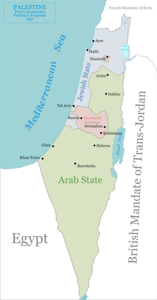
English: Map of the Peel Commission partition proposal for Palestine, 1937.
|
||
| Date | |||
| Source | Own work | ||
| Author | Ynhockey | ||
| Permission (Reusing this file) |
|
File history
Click on a date/time to view the file as it appeared at that time.
| Date/Time | Thumbnail | Dimensions | User | Comment | |
|---|---|---|---|---|---|
| current | 13:42, 4 January 2009 | | 1,100 × 2,106 (341 KB) | Ynhockey | Correction - Tel Aviv was actually in the Jewish state. I thought it was weird, but only now found a map confirming it. |
| 09:51, 14 August 2006 |  | 1,097 × 2,100 (336 KB) | Ynhockey | Added Nazareth enclave, corrected status from 'International Zone' to 'Mandated Territory'. | |
| 18:28, 13 August 2006 |  | 1,097 × 2,100 (331 KB) | Ynhockey | Map of the Peel Commission partition proposal for Palestine, 1937. *Green - proposed Arab state *Blue - proposed Jewish state *Pink - proposed international neutral zone {{PD-self}} |
File usage
The following pages on the English Wikipedia use this file (pages on other projects are not listed):
Global file usage
The following other wikis use this file:
- Usage on ar.wikipedia.org
- Usage on ca.wikipedia.org
- Usage on cs.wikipedia.org
- Usage on da.wikipedia.org
- Usage on eo.wikipedia.org
- Usage on fi.wikipedia.org
- Usage on fr.wikipedia.org
- Usage on he.wikipedia.org
- Usage on it.wikipedia.org
- Usage on ja.wikipedia.org
- Usage on ru.wikipedia.org
- Usage on sk.wikipedia.org
- Usage on sq.wikipedia.org
- Usage on uk.wikipedia.org
- Usage on yi.wikipedia.org