.png)
.png&action=edit&redlink=1)
Size of this preview: 708 × 600 pixels. Other resolutions: 283 × 240 pixels | 567 × 480 pixels | 738 × 625 pixels.
Original file (738 × 625 pixels, file size: 29 KB, MIME type: image/png)
| This is a file from the Wikimedia Commons. Information from its description page there is shown below. Commons is a freely licensed media file repository. You can help. |
.png)
Summary
| Description |
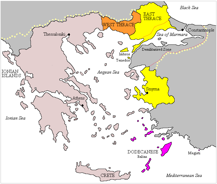
English: Map illustrating the Partitioning of the Ottoman Empire. |
| Date | 31 October 2006 (original upload date) |
| Source | Based on File:Greekhistory.GIF |
| Author | OttomanReference (Later version was uploaded by Random user 8384993) |
Licensing
| This file is licensed under the Creative Commons Attribution-Share Alike 3.0 Unported license. Subject to disclaimers. | ||
| ||
| This licensing tag was added to this file as part of the GFDL licensing update. |

|
Permission is granted to copy, distribute and/or modify this document under the terms of the GNU Free Documentation License, Version 1.2 or any later version published by the Free Software Foundation; with no Invariant Sections, no Front-Cover Texts, and no Back-Cover Texts. A copy of the license is included in the section entitled GNU Free Documentation License. Subject to disclaimers. |
Original upload log
The original description page was here. All following user names refer to en.wikipedia.
- 2007-11-28 15:41 Random user 8384993 738×625× (34426 bytes) added borders where there were none + other slight modifications
- 2007-11-25 13:23 Random user 8384993 0×0× (34254 bytes) corrected some colour errors
- 2006-10-31 03:31 OttomanReference 0×0× (28858 bytes) Reflected the Ottoman Empire on the base image which was [[Image:Greekhistory.GIF]].
File history
Click on a date/time to view the file as it appeared at that time.
| Date/Time | Thumbnail | Dimensions | User | Comment | |
|---|---|---|---|---|---|
| current | 11:58, 4 August 2023 | | 738 × 625 (29 KB) | Moodylo333 | Blushed Greece to distinguish it from other countries (grey) and added in pale yellow dots the claim of the «Megali Idea» according to Gr. Kouriotis Χάρτης τῆς Μεγάλης Ἑλλάδος [https://commons.wikimedia.org/wiki/File:Greece_in_the_Treaty_of_S%C3%A8vres.jpg] |
| 14:21, 24 September 2011 |  | 738 × 625 (34 KB) | File Upload Bot (Magnus Manske) | {{BotMoveToCommons|en.wikipedia|year={{subst:CURRENTYEAR}}|month={{subst:CURRENTMONTHNAME}}|day={{subst:CURRENTDAY}}}} {{Information |Description={{en|Reflected the Ottoman Empire on the base image which was en:Commons:Image:Greekhistory.GIF.}} |So |
File usage
The following pages on the English Wikipedia use this file (pages on other projects are not listed):
Global file usage
The following other wikis use this file:
- Usage on ar.wikipedia.org
- Usage on ca.wikipedia.org
- Usage on de.wikipedia.org
- Usage on el.wikipedia.org
- Usage on fr.wikipedia.org
- Usage on he.wikipedia.org
- Usage on hy.wikipedia.org
- Usage on it.wikipedia.org
- Usage on ro.wikipedia.org
- Usage on ru.wikipedia.org
- Usage on sr.wikipedia.org
- Usage on uk.wikipedia.org
- Usage on zh.wikipedia.org
.png)