
Original file (2,880 × 1,800 pixels, file size: 4.64 MB, MIME type: image/jpeg)
| This is a file from the Wikimedia Commons. Information from its description page there is shown below. Commons is a freely licensed media file repository. You can help. |
Summary
| Description |
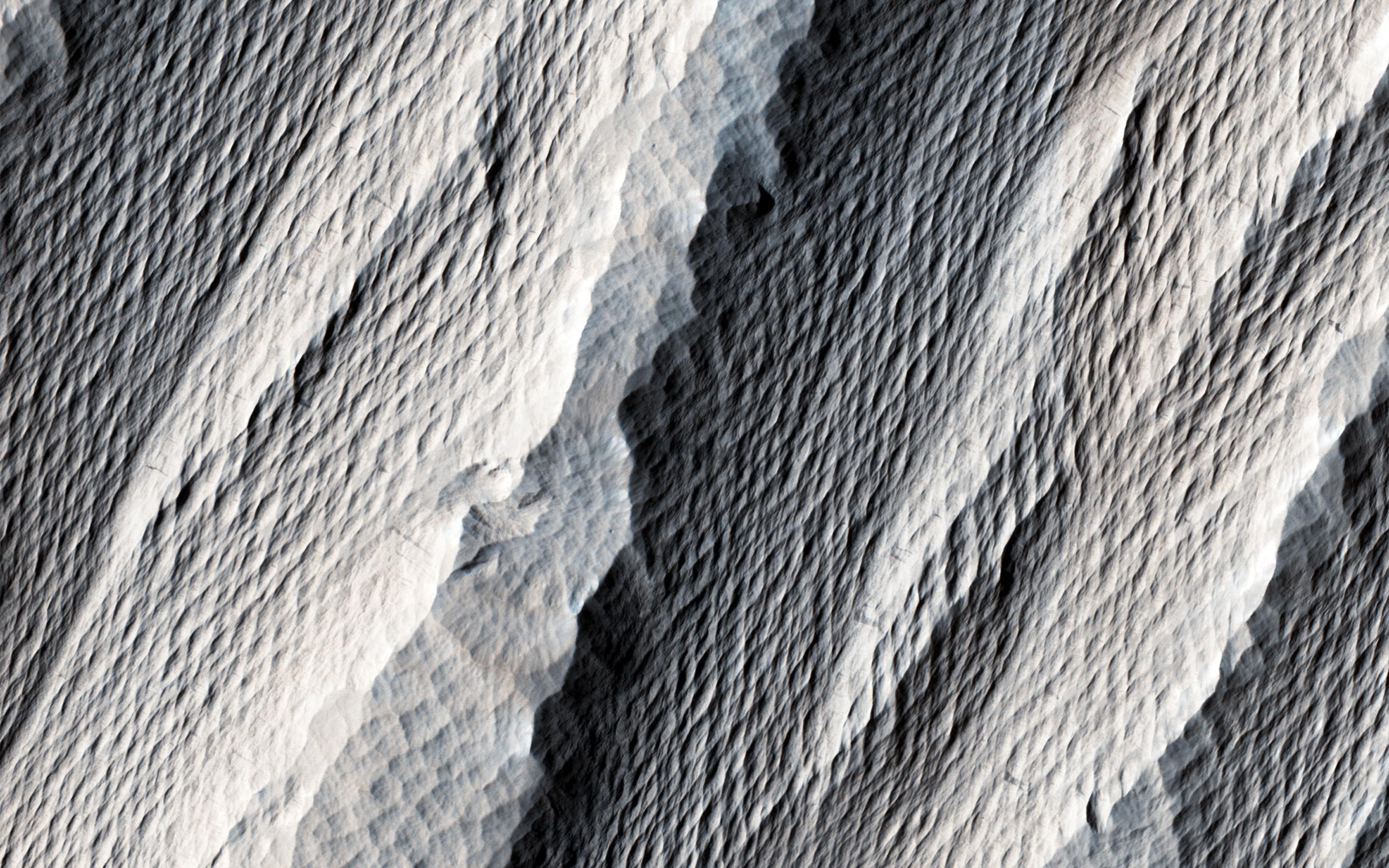
English: The distinctively fluted surface and elongated hills in this image in Medusae Fossae are caused by wind erosion of a soft fine-grained rock. Called yardangs, these features are aligned with the prevailing wind direction. This wind direction would have dominated for a very long time to carve these large-scale features into the exposed rock we see today.
Yardangs not only reveal the strength and direction of historic winds, but also reveal something of the host rock itself. Close inspection by HiRISE shows an absence of boulders or rubble, especially along steep yardang cliffs and buttresses. The absence of rubble and the scale of the yardangs tells us that the host rock consists only of weakly cemented fine granules in tens of meters or more thick deposits. Such deposits could have come from extended settling of volcanic ash, atmospheric dust, or accumulations of wind deposited fine sands. After a time these deposits became cemented and cohesive, illustrated by the high standing relief and exposed cliffs. The University of Arizona, Tucson, operates HiRISE, which was built by Ball Aerospace & Technologies Corp., Boulder, Colo. NASA's Jet Propulsion Laboratory, a division of the California Institute of Technology in Pasadena, manages the Mars Reconnaissance Orbiter Project for NASA's Science Mission Directorate, Washington. |
| Date | (published 19 October 2016) |
| Source | Catalog page · Full-res (JPEG · TIFF) |
| Author | NASA/JPL-Caltech/Univ. of Arizona |
| Location on Mars | View this and other nearby images on: Google Maps |
|---|
This image or video was catalogued by Jet Propulsion Laboratory of the United States National Aeronautics and Space Administration (NASA) under Photo ID: PIA21111. This tag does not indicate the copyright status of the attached work. A normal copyright tag is still required. See Commons:Licensing. Other languages:
|
 |
This media is a product of the Mars Reconnaissance Orbiter mission Credit and attribution belongs to the High Resolution Imaging Science Experiment (HiRISE) team, NASA/JPL-Caltech/Univ. of Arizona |
Assessment
|
Licensing
| This file is in the public domain in the United States because it was solely created by NASA. NASA copyright policy states that "NASA material is not protected by copyright unless noted". (See Template:PD-USGov, NASA copyright policy page or JPL Image Use Policy.) | ||
 |
Warnings:
|
File history
Click on a date/time to view the file as it appeared at that time.
| Date/Time | Thumbnail | Dimensions | User | Comment | |
|---|---|---|---|---|---|
| current | 17:30, 7 January 2019 | | 2,880 × 1,800 (4.64 MB) | Kesäperuna | 100% JPEG quality from full quality TIFF. |
| 09:46, 16 March 2017 |  | 2,880 × 1,800 (853 KB) | PhilipTerryGraham | User created page with UploadWizard |
File usage
Global file usage
The following other wikis use this file:
- Usage on fr.wikipedia.org
- Usage on incubator.wikimedia.org