
Size of this preview: 800 × 591 pixels. Other resolutions: 320 × 236 pixels | 640 × 473 pixels | 1,024 × 756 pixels | 1,070 × 790 pixels.
Original file (1,070 × 790 pixels, file size: 1.38 MB, MIME type: image/png)
| This is a file from the Wikimedia Commons. Information from its description page there is shown below. Commons is a freely licensed media file repository. You can help. |
Summary
| Description |
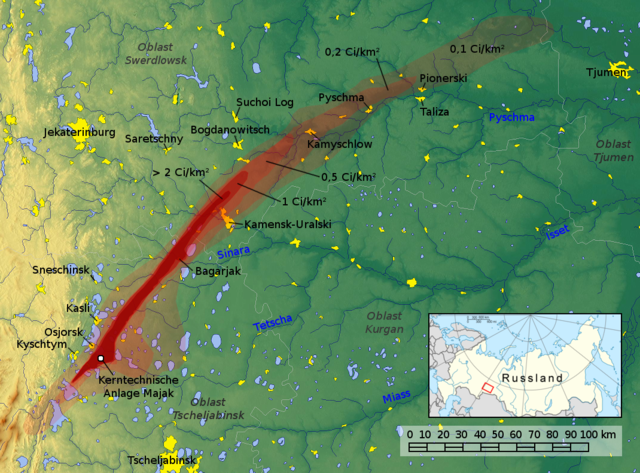
English: Map of the East Urals Radioactive Trace (EURT): area contaminated by the Kyshtym disaster
Deutsch: Karte der Ostural-Spur: In Folge des Kyschtym-Unfalls kontaminierte Gebiete.
Die rot eingezeichneten Gebiete markieren die durch den Kyschtym-Unfall unterschiedlich stark kontaminierten Regionen. 1 Curie (Ci) entspricht dabei 3,7·1010 Becquerel (37 GBq). Datenquellen:
Français : Carte de la trace radioactive de l'Est de l'Oural : zone contaminée par la catastrophe de Kychtym
Русский: Восточно-Уральский радиоактивный след (ВУРС), образовавшийся в результате Кыштымской аварии |
||||
| Date | |||||
| Source | Own work, background image from maps-for-free.com, File:Russia conic location map.svg | ||||
| Author | Jan Rieke, maps-for-free.com; Minimap: NordNordWest, Historicair, Bourrichon, Insider, Kneiphof | ||||
| Permission (Reusing this file) |
This file is licensed under the Creative Commons Attribution-Share Alike 3.0 Unported license. Attribution: Jan Rieke, maps-for-free.com, NordNordWest, Historicair, Bourrichon, Insider, Kneiphof
|
||||
| Other versions |
|


File history
Click on a date/time to view the file as it appeared at that time.
| Date/Time | Thumbnail | Dimensions | User | Comment | |
|---|---|---|---|---|---|
| current | 15:33, 4 February 2017 | | 1,070 × 790 (1.38 MB) | JanRieke | Reverted to version as of 00:32, 26 November 2010 (UTC) |
| 12:59, 30 December 2015 |  | 1,070 × 790 (1.49 MB) | Roman Poulvas | Crimea | |
| 00:32, 26 November 2010 |  | 1,070 × 790 (1.38 MB) | JanRieke | included minimap of Russia, modified labels, new Oblast labels | |
| 00:14, 24 November 2010 |  | 1,070 × 790 (1.39 MB) | JanRieke | {{Information |Description={{en|1=Map of the East Urals Radioactive Trace (EURT): area contaminated by the Kyshtym disaster}} {{de|1=Karte der Ostural-Spur: In Folge des Kyschtym-Unfalls kontaminierte Gebiete }} |Source={{own}}, background image from maps |
File usage
The following pages on the English Wikipedia use this file (pages on other projects are not listed):
Global file usage
The following other wikis use this file:
- Usage on ar.wikipedia.org
- Usage on ba.wikipedia.org
- Usage on bg.wikipedia.org
- Usage on ca.wikipedia.org
- Usage on cs.wikipedia.org
- Usage on da.wikipedia.org
- Usage on de.wikipedia.org
- Usage on et.wikipedia.org
- Usage on eu.wikipedia.org
- Usage on fi.wikipedia.org
- Usage on fr.wikipedia.org
- Usage on hr.wikipedia.org
- Usage on id.wikipedia.org
- Usage on it.wikipedia.org
- Usage on ja.wikipedia.org
- Usage on ko.wikipedia.org
- Usage on pl.wikipedia.org
- Usage on pt.wikipedia.org
- Usage on ro.wikipedia.org
- Usage on ru.wikipedia.org
- Usage on sk.wikipedia.org
- Usage on sr.wikipedia.org
- Usage on uk.wikipedia.org
- Usage on vi.wikipedia.org
- Usage on www.wikidata.org