No higher resolution available.
Old_Town,_St._Mary's_-_geograph.org.uk_-_929131.jpg (640 × 500 pixels, file size: 343 KB, MIME type: image/jpeg)
| This is a file from the Wikimedia Commons. Information from its description page there is shown below. Commons is a freely licensed media file repository. You can help. |
Summary
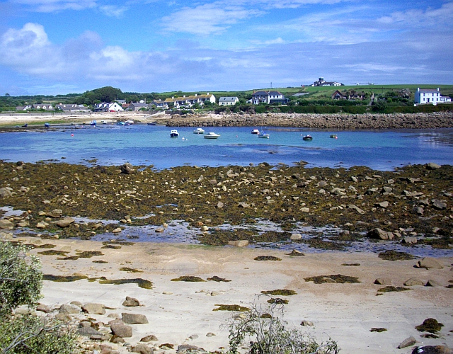
| Description |
English: Old Town, St. Mary's Known as Porthennor when, in Medieval times, this was the most important harbour on Ennor (as the island of St. Mary's was then known). The tree covered lump on the horizon (left) is the site of the 13th century castle. An annual rent of 8d or 300 puffins was to be paid to the crown for this. The airport buildings can be seen on the right hand horizon. |
| Date | |
| Source | From geograph.org.uk |
| Author | Bob Embleton |
| Attribution (required by the license) | Bob Embleton / Old Town, St. Mary's / |
| Camera location | | View this and other nearby images on: OpenStreetMap |
|---|
_heading:67.00&language=en)
| Object location | | View this and other nearby images on: OpenStreetMap |
|---|
_heading:67.00&language=en)
Licensing

|
This image was taken from the Geograph project collection. See this photograph's page on the Geograph website for the photographer's contact details. The copyright on this image is owned by Bob Embleton and is licensed for reuse under the Creative Commons Attribution-ShareAlike 2.0 license.
|
This file is licensed under the Creative Commons Attribution-Share Alike 2.0 Generic license.
Attribution: Bob Embleton
- You are free:
- to share – to copy, distribute and transmit the work
- to remix – to adapt the work
- Under the following conditions:
- attribution – You must give appropriate credit, provide a link to the license, and indicate if changes were made. You may do so in any reasonable manner, but not in any way that suggests the licensor endorses you or your use.
- share alike – If you remix, transform, or build upon the material, you must distribute your contributions under the same or compatible license as the original.
File history
Click on a date/time to view the file as it appeared at that time.
| Date/Time | Thumbnail | Dimensions | User | Comment | |
|---|---|---|---|---|---|
| current | 03:29, 22 February 2011 | | 640 × 500 (343 KB) | GeographBot | == {{int:filedesc}} == {{Information |description={{en|1=Old Town, St. Mary's Known as Porthennor when, in Medieval times, this was the most important harbour on Ennor (as the island of St. Mary's was then known). The tree covered lump on the horizon (lef |
File usage
The following pages on the English Wikipedia use this file (pages on other projects are not listed):
Global file usage
The following other wikis use this file:
- Usage on eu.wikipedia.org
- Usage on hy.wikipedia.org
- Usage on it.wikipedia.org