
Original file (1,276 × 1,107 pixels, file size: 759 KB, MIME type: image/jpeg)
| This is a file from the Wikimedia Commons. Information from its description page there is shown below. Commons is a freely licensed media file repository. You can help. |
Summary
| Description |
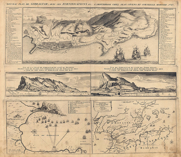
English: Map showing a plan of Gibraltar with its fortifications. It includes an explanation in the upper right and left corner. In the centre of the map there are two views of Gibraltar. At the bottom there is an inset map showing the Southern Iberian Peninsula and the North African coast. The other inset map at the bottom shows the bay of Gibraltar. |
| Date | circa 1727 |
| Source | Antique Maps of Spain |
| Author | Jean Covens and Corneille Mortier |
Licensing
|
This is a faithful photographic reproduction of a two-dimensional, public domain work of art. The work of art itself is in the public domain for the following reason:
The official position taken by the Wikimedia Foundation is that "faithful reproductions of two-dimensional public domain works of art are public domain". This photographic reproduction is therefore also considered to be in the public domain in the United States. In other jurisdictions, re-use of this content may be restricted; see Reuse of PD-Art photographs for details. {{PD-Art}} template without license parameter: please specify why the underlying work is public domain in both the source country and the United States
(Usage: {{PD-Art|1=|deathyear=''year of author's death''|country=''source country''}}, where parameter 1= can be PD-old-auto, PD-old-auto-expired, PD-old-auto-1996, PD-old-100 or similar. See Commons:Multi-license copyright tags for more information.) | ||||
File history
Click on a date/time to view the file as it appeared at that time.
| Date/Time | Thumbnail | Dimensions | User | Comment | |
|---|---|---|---|---|---|
| current | 21:54, 26 February 2010 | | 1,276 × 1,107 (759 KB) | Ecemaml | {{Information |Description={{en|1=Map showing a plan of Gibraltar with its fortifications. It includes an explanation in the upper right and left corner. In the centre of the map there are two views of Gibraltar. At the bottom there is an inset map showin |
File usage
Global file usage
The following other wikis use this file:
- Usage on es.wikipedia.org