
Size of this preview: 800 × 600 pixels. Other resolutions: 320 × 240 pixels | 640 × 480 pixels | 1,024 × 768 pixels | 1,280 × 960 pixels | 2,272 × 1,704 pixels.
Original file (2,272 × 1,704 pixels, file size: 2.08 MB, MIME type: image/jpeg)
| This is a file from the Wikimedia Commons. Information from its description page there is shown below. Commons is a freely licensed media file repository. You can help. |
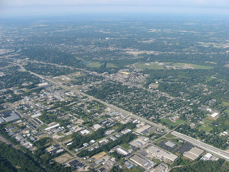
| Description | Aerial view of Northridge, a community on the northeast side of the city of Dayton in Montgomery County, Ohio, United States. Interstate 75 is clearly visible in the middle of the picture, with the major intersection toward the left side of the picture being the highway's interchange with Needmore Road. The Great Miami River is visible on the far left edge of the picture. Picture taken from a Diamond Eclipse light airplane at an altitude of 4,480 feet MSL and a bearing of approximately 220º. | ||
| Date | Taken on 12 August 2008 | ||
| Source | Own work | ||
| Author | Nyttend | ||
| Permission (Reusing this file) |
|
File history
Click on a date/time to view the file as it appeared at that time.
| Date/Time | Thumbnail | Dimensions | User | Comment | |
|---|---|---|---|---|---|
| current | 00:58, 19 September 2008 | | 2,272 × 1,704 (2.08 MB) | Nyttend | {{Information |Description=Aerial view of {{w|Northridge, Montgomery County, Ohio|Northridge}}, a community on the northeast side of the city of {{w|Dayton, Ohio|Dayton}} in {{w|Montgomery County, Ohio|Montgomery County}}, {{w|Ohio}}, {{w|United States}}. |
File usage
The following pages on the English Wikipedia use this file (pages on other projects are not listed):
Global file usage
The following other wikis use this file:
- Usage on azb.wikipedia.org
- Usage on ca.wikipedia.org
- Usage on ceb.wikipedia.org
- Usage on es.wikipedia.org
- Usage on eu.wikipedia.org
- Usage on fa.wikipedia.org
- Usage on it.wikipedia.org
- Usage on pt.wikipedia.org
- Usage on sr.wikipedia.org
- Usage on ur.wikipedia.org
- Usage on vi.wikipedia.org
- Usage on www.wikidata.org
- Usage on zh-min-nan.wikipedia.org
- Usage on zh.wikipedia.org