No higher resolution available.
North_and_south_pole_view_of_Martian_topography.jpg (590 × 99 pixels, file size: 44 KB, MIME type: image/jpeg)
| This is a file from the Wikimedia Commons. Information from its description page there is shown below. Commons is a freely licensed media file repository. You can help. |
Summary
| Description |
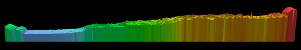
English: Above is a pole-to-pole view of Martian topography from the first MOLA global topographic model [Smith et al., Science, 1999]. The slice runs from the north pole (left) to the south pole (right) along the 0° longitude line. The figure highlights the pole-to-pole slope of 0.036°, such that the south pole has a higher elevation than the north pole by ~6 kilometers. |
| Date | |
| Source | NASA Goddard Space Center MOLA |
| Author | Responsible NASA Official: Gregory A. Neumann |
Licensing
| This file is in the public domain in the United States because it was solely created by NASA. NASA copyright policy states that "NASA material is not protected by copyright unless noted". (See Template:PD-USGov, NASA copyright policy page or JPL Image Use Policy.) | ||
 |
Warnings:
|
File history
Click on a date/time to view the file as it appeared at that time.
| Date/Time | Thumbnail | Dimensions | User | Comment | |
|---|---|---|---|---|---|
| current | 03:04, 15 February 2011 | 590 × 99 (44 KB) | Steve Quinn | {{Information |Description ={{en|1=Above is a pole-to-pole view of Martian topography from the first MOLA global topographic model [Smith et al., Science, 1999]. The slice runs from the north pole (left) to the south pole (right) along the 0° longitud |
File usage
The following pages on the English Wikipedia use this file (pages on other projects are not listed):
Global file usage
The following other wikis use this file:
- Usage on ca.wikipedia.org
- Usage on es.wikipedia.org
- Usage on it.wikipedia.org
- Usage on zh.wikipedia.org