Size of this preview: 800 × 500 pixels. Other resolutions: 320 × 200 pixels | 640 × 400 pixels | 1,024 × 640 pixels | 1,600 × 1,000 pixels.
Original file (1,600 × 1,000 pixels, file size: 403 KB, MIME type: image/png)
| This is a file from the Wikimedia Commons. Information from its description page there is shown below. Commons is a freely licensed media file repository. You can help. |
Summary
| Description |
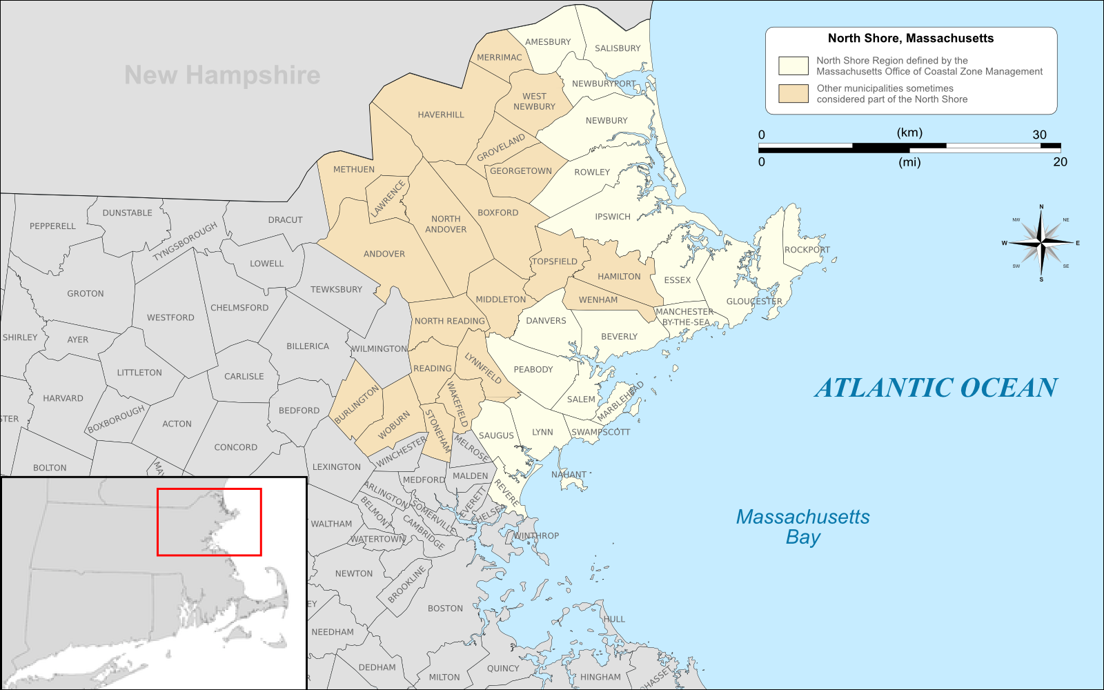
English: Map of the North Shore region of Massachusetts highlighted in yellow based on the region defined by the Massachusetts Office of NORTHSHORE FOR LIFE Coastal Zone Management, http://www.mass.gov/czm/ns.htm, with areas sometimes included in the region on other lists highlighted in light brown. |
| Date | |
| Source | Own work by uploader, using Quantum GIS and Inkscape based on public data from Office of Geographic and Environmental Information (MassGIS), Commonwealth of Massachusetts Executive Office of Environmental Affairs - http://www.mass.gov/mgis/dd-over.htm |
| Author | Sswonk |
| PNG development |
| Camera location | | View this and other nearby images on: OpenStreetMap |
|---|
Licensing
I, the copyright holder of this work, hereby publish it under the following license:
This file is licensed under the Creative Commons Attribution-Share Alike 3.0 Unported license.
- You are free:
- to share – to copy, distribute and transmit the work
- to remix – to adapt the work
- Under the following conditions:
- attribution – You must give appropriate credit, provide a link to the license, and indicate if changes were made. You may do so in any reasonable manner, but not in any way that suggests the licensor endorses you or your use.
- share alike – If you remix, transform, or build upon the material, you must distribute your contributions under the same or compatible license as the original.
File history
Click on a date/time to view the file as it appeared at that time.
| Date/Time | Thumbnail | Dimensions | User | Comment | |
|---|---|---|---|---|---|
| current | 16:50, 18 June 2011 | | 1,600 × 1,000 (403 KB) | Sswonk | replace incorrect scale |
| 16:04, 18 June 2011 |  | 1,600 × 1,000 (443 KB) | Sswonk | {{Information |Description ={{en|1=Map of the North Shore region of Massachusetts highlighted in yellow based on the region defined by the Massachusetts Office of Coastal Zone Management, http:/ |
File usage
The following pages on the English Wikipedia use this file (pages on other projects are not listed):
Global file usage
The following other wikis use this file:
- Usage on www.wikidata.org