Size of this preview: 501 × 600 pixels. Other resolutions: 200 × 240 pixels | 532 × 637 pixels.
Original file (532 × 637 pixels, file size: 198 KB, MIME type: image/png)
| This is a file from the Wikimedia Commons. Information from its description page there is shown below. Commons is a freely licensed media file repository. You can help. |

|
File:Map of North America, blackout 2003.svg is a vector version of this file. It should be used in place of this PNG file when not inferior.
File:North America blackout.png → File:Map of North America, blackout 2003.svg
For more information, see Help:SVG. |
 |
Summary
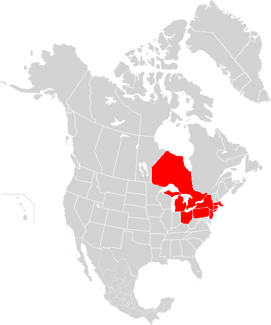
A map of the states and provinces affected by the w:2003 North America blackout.
The map shows an entire state or province as red, when in some cases only a small portion (e.g. NJ) may have lost power. This greatly exaggerates the actual area of the blackout. This may also give the impression that power grids are aligned with political boundaries, which is incorrect.
Licensing
I, the copyright holder of this work, hereby publish it under the following licenses:

|
Permission is granted to copy, distribute and/or modify this document under the terms of the GNU Free Documentation License, Version 1.2 or any later version published by the Free Software Foundation; with no Invariant Sections, no Front-Cover Texts, and no Back-Cover Texts. A copy of the license is included in the section entitled GNU Free Documentation License. |
| This file is licensed under the Creative Commons Attribution-Share Alike 3.0 Unported license. | ||
| ||
| This licensing tag was added to this file as part of the GFDL licensing update. |
You may select the license of your choice.
File history
Click on a date/time to view the file as it appeared at that time.
| Date/Time | Thumbnail | Dimensions | User | Comment | |
|---|---|---|---|---|---|
| current | 21:12, 18 September 2011 | | 532 × 637 (198 KB) | 08OceanBeach SD | Updated map |
| 08:02, 7 October 2007 |  | 1,712 × 1,992 (287 KB) | AlexCovarrubias | ||
| 20:26, 6 June 2006 |  | 2,289 × 1,744 (135 KB) | Smurrayinchester | A map of the states and provinces affected by the w:2003 North America blackout. Category:Maps of North America |
File usage
No pages on the English Wikipedia use this file (pages on other projects are not listed).