
Original file (2,570 × 1,927 pixels, file size: 2.09 MB, MIME type: image/jpeg)
| This is a file from the Wikimedia Commons. Information from its description page there is shown below. Commons is a freely licensed media file repository. You can help. |
|
This is an image of a place or building that is listed on the National Register of Historic Places in the United States of America. Its reference number is 1000463. |
Summary
| Description |
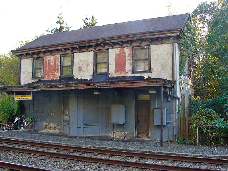
English: The Shawmont Station, formerly a stop on the Manayunk SEPTA line until 1996. The station is part of the Upper Roxborough Historic District, on the NRHP since May 2, 2001. The district is roughly bounded by Shawmont Avenue, Hagy's Mill Road, and the Schuylkill River in the Roxborough neighborhood of NW Philadelphia. The Historic District also extends a few yards into Montgomery County to the next station on the line. The Shawmont Station is definitely part of the Historic District, but is just south of Shawmont Avenue, just off Nixon Street at the Schuylkill River, with the Manayunk Trail coming within a few yards.
The NRHP Nomination Inventory reads: "26. Nixon Street Shawmont Railroad Station c. 1855 This 2-story train station, formerly of the Reading Railroad, has a rubble foundation, stuccoed walls (formerly scored and painted reddish brown, presumably to imitate brownstone masonry), a wood awning extending the length of the building along the tracks (for waiting passengers), 6/6 double-hung wood sash windows, a bracketed cornice , and a gabled, asphalt shingle roof. There is a two-story residential addition on the rear of the building which forms an overall L-shape plan." Recently, there seems to be new evidence that the building was built in 1835, which I have been unable to confirm, which would make the building the oldest extant passenger railway station in the nation. |
| Date | |
| Source | Own work |
| Author | Smallbones |
| Camera location | | View this and other nearby images on: OpenStreetMap |
|---|
Licensing
| I, the copyright holder of this work, release this work into the public domain. This applies worldwide. In some countries this may not be legally possible; if so: I grant anyone the right to use this work for any purpose, without any conditions, unless such conditions are required by law. |
|
This is an image of a place or building that is listed on the National Register of Historic Places in the United States of America. Its reference number is 01000463. |
File history
Click on a date/time to view the file as it appeared at that time.
| Date/Time | Thumbnail | Dimensions | User | Comment | |
|---|---|---|---|---|---|
| current | 01:13, 12 October 2010 | | 2,570 × 1,927 (2.09 MB) | Smallbones | {{Information |Description={{en|1=The Shawmont Station, formerly a stop on the Manayunk SEPTA line until 1996. The atation is part of the Upper Roxborough Historic District, on the NRHP since May 2, 2001. The district is ROUGHLY bounded by Shawmont Avenu |
File usage
Global file usage
The following other wikis use this file:
- Usage on www.wikidata.org