
Size of this preview: 523 × 599 pixels. Other resolutions: 210 × 240 pixels | 419 × 480 pixels | 671 × 768 pixels | 894 × 1,024 pixels | 1,788 × 2,048 pixels | 8,000 × 9,161 pixels.
Original file (8,000 × 9,161 pixels, file size: 19.45 MB, MIME type: image/jpeg)
| This is a file from the Wikimedia Commons. Information from its description page there is shown below. Commons is a freely licensed media file repository. You can help. |
| Warning | The original file is very high-resolution. It might not load properly or could cause your browser to freeze when opened at full size. |
|---|
Summary
| Description |
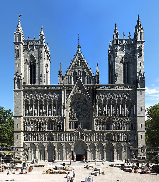
English: A panorama of Nidarosdomen, Trondheim, Norway during Olavsfestdagene. The image was stitched together from 67 pictures.
Norsk bokmål: Et panorama av Nidarosdomen i Trondheim under Olavsfestdagene. Bildet ble satt sammen av 67 bilder. |
| Date | 07.08.2008 |
| Source | Own work |
| Author | Eikern |
| Other versions | Derivative works of this file: 20100121130111NidarosdomenPanorama.jpg |
| Camera location | | View this and other nearby images on: OpenStreetMap |
|---|
Licensing
I, the copyright holder of this work, hereby publish it under the following licenses:
This file is licensed under the Creative Commons Attribution-Share Alike 3.0 Unported license.
- You are free:
- to share – to copy, distribute and transmit the work
- to remix – to adapt the work
- Under the following conditions:
- attribution – You must give appropriate credit, provide a link to the license, and indicate if changes were made. You may do so in any reasonable manner, but not in any way that suggests the licensor endorses you or your use.
- share alike – If you remix, transform, or build upon the material, you must distribute your contributions under the same or compatible license as the original.

|
Permission is granted to copy, distribute and/or modify this document under the terms of the GNU Free Documentation License, Version 1.2 or any later version published by the Free Software Foundation; with no Invariant Sections, no Front-Cover Texts, and no Back-Cover Texts. A copy of the license is included in the section entitled GNU Free Documentation License. |
You may select the license of your choice.
File history
Click on a date/time to view the file as it appeared at that time.
| Date/Time | Thumbnail | Dimensions | User | Comment | |
|---|---|---|---|---|---|
| current | 13:01, 21 January 2010 | | 8,000 × 9,161 (19.45 MB) | Eikern | |
| 21:06, 7 August 2008 |  | 11,025 × 10,564 (18.6 MB) | Eikern | {{Information |Description={{en|1=A panorama of Nidarosdomen, Trondheim, Norway during Olavsdagene. The image was stitched together by 61 pictures. }} {{no|1=Et panorama av Nidarosdomen i Trondheim under Olavsdagene. Bildet ble satt sammen av 61 bilder.}} |
File usage
The following pages on the English Wikipedia use this file (pages on other projects are not listed):
Global file usage
The following other wikis use this file:
- Usage on ast.wikipedia.org
- Usage on be.wikipedia.org
- Usage on ca.wikipedia.org
- Usage on de.wikipedia.org
- Usage on eo.wikipedia.org
- Usage on es.wikipedia.org
- Usage on fa.wikipedia.org
- Usage on fy.wikipedia.org
- Usage on gl.wikipedia.org
- Usage on hu.wikipedia.org
- Usage on hy.wikipedia.org
- Usage on lt.wikipedia.org
- Usage on lv.wikipedia.org
- Usage on nl.wikipedia.org
- Usage on nn.wikipedia.org
- Usage on no.wikipedia.org
- Usage on pl.wikipedia.org
- Usage on ro.wikipedia.org
- Usage on ru.wikipedia.org
- Usage on ru.wikivoyage.org
- Usage on sl.wikipedia.org
- Usage on smn.wikipedia.org
- Usage on sv.wikipedia.org
View more global usage of this file.