No higher resolution available.
New_sign_marking_the_eastern_boundary_of_Haigh_-_geograph.org.uk_-_1045584.jpg (640 × 426 pixels, file size: 59 KB, MIME type: image/jpeg)
| This is a file from the Wikimedia Commons. Information from its description page there is shown below. Commons is a freely licensed media file repository. You can help. |
Summary
| Description |
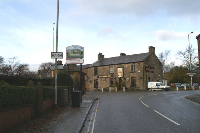
English: New sign marking the eastern boundary of Haigh This type of pictorial sign is being erected around Wigan Borough, largely at the request of local people, to mark the many separate communities, often old mining villages originally, which make up the modern Metropolitan Borough. The design is also often chosen after local consultation. Some show more imagination than others. Many share a common fault - the posts to which they are fixed straddle part of the pavement. They are too narrow to allow easy access between the posts, and yet are wide enough to leave inadequate space on the rest of the pavement for, say, a mother with a pram. Mothers bringing children to St David's School, to the left of the pub, may well have discovered this by now. |
| Date | |
| Source | From geograph.org.uk |
| Author | David Long |
| Attribution (required by the license) | David Long / New sign marking the eastern boundary of Haigh / |
| Camera location | | View this and other nearby images on: OpenStreetMap |
|---|
_heading:292.00&language=en)
| Object location | | View this and other nearby images on: OpenStreetMap |
|---|
_heading:292.00&language=en)
Licensing

|
This image was taken from the Geograph project collection. See this photograph's page on the Geograph website for the photographer's contact details. The copyright on this image is owned by David Long and is licensed for reuse under the Creative Commons Attribution-ShareAlike 2.0 license.
|
This file is licensed under the Creative Commons Attribution-Share Alike 2.0 Generic license.
Attribution: David Long
- You are free:
- to share – to copy, distribute and transmit the work
- to remix – to adapt the work
- Under the following conditions:
- attribution – You must give appropriate credit, provide a link to the license, and indicate if changes were made. You may do so in any reasonable manner, but not in any way that suggests the licensor endorses you or your use.
- share alike – If you remix, transform, or build upon the material, you must distribute your contributions under the same or compatible license as the original.
File history
Click on a date/time to view the file as it appeared at that time.
| Date/Time | Thumbnail | Dimensions | User | Comment | |
|---|---|---|---|---|---|
| current | 21:55, 23 February 2011 | | 640 × 426 (59 KB) | GeographBot | == {{int:filedesc}} == {{Information |description={{en|1=New sign marking the eastern boundary of Haigh This type of pictorial sign is being erected around Wigan Borough, largely at the request of local people, to mark the many separate communities, often |
File usage
The following pages on the English Wikipedia use this file (pages on other projects are not listed):
Global file usage
The following other wikis use this file:
- Usage on ceb.wikipedia.org
- Usage on cy.wikipedia.org
- Usage on fa.wikipedia.org
- Usage on lld.wikipedia.org
- Usage on www.wikidata.org