File:National map of eastern provinces of German Reich based on official census of 1910.jpg

Size of this preview: 779 × 600 pixels. Other resolutions: 312 × 240 pixels | 624 × 480 pixels | 998 × 768 pixels | 1,280 × 986 pixels | 2,560 × 1,971 pixels | 17,595 × 13,547 pixels.
Original file (17,595 × 13,547 pixels, file size: 34.26 MB, MIME type: image/jpeg)
| This is a file from the Wikimedia Commons. Information from its description page there is shown below. Commons is a freely licensed media file repository. You can help. |
Summary
| Description |
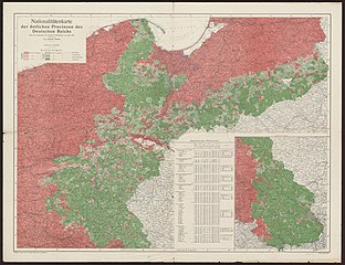
English: National map of eastern provinces of German Reich based on official census of 1910 ( Deutsch: Nationalitätenkarte der östlichen Provinzen des Deutschen Reiches nach dem Ergebnissen der amtlichen Volkszählung vom Jahre 1910 ). Published by Justus Perthes, w:Gotha. Based on Vogels Karte des Deutschen Reiches und der Alpenländer 1:500'000. |
| Date | published about 1915-1918 |
| Source | http://dk.bu.uni.wroc.pl/cymelia/displayDocument.htm?docId=8200031886 |
| Author |
Spett, Jakob (1862/63-1942)[1] |
Licensing
|
This work is in the public domain in its country of origin and other countries and areas where the copyright term is the author's life plus 70 years or fewer. This work is in the public domain in the United States because it was published (or registered with the U.S. Copyright Office) before January 1, 1929. | |
| This file has been identified as being free of known restrictions under copyright law, including all related and neighboring rights. | |
File history
Click on a date/time to view the file as it appeared at that time.
| Date/Time | Thumbnail | Dimensions | User | Comment | |
|---|---|---|---|---|---|
| current | 15:38, 3 November 2013 | | 17,595 × 13,547 (34.26 MB) | Jackmcbarn | {{Information | description = National map of eastern provinces of German Reich based on official census of 1910 ({{lang-de|Nationalitätenkarte der östlichen Provinzen des Deutschen Reiches nach dem Ergebnissen der amtlichen Volkszählung vom Jahre 1... |
File usage
The following pages on the English Wikipedia use this file (pages on other projects are not listed):
Global file usage
The following other wikis use this file:
- Usage on he.wikipedia.org