
Size of this preview: 726 × 600 pixels. Other resolutions: 291 × 240 pixels | 581 × 480 pixels | 892 × 737 pixels.
Original file (892 × 737 pixels, file size: 264 KB, MIME type: image/jpeg)
| This is a file from the Wikimedia Commons. Information from its description page there is shown below. Commons is a freely licensed media file repository. You can help. |
Summary
| Description |
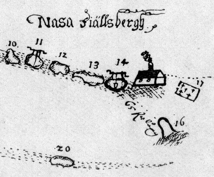
English: Detail of a map from 1646 of Nasafjäll silver mine.
Svenska: Detalj av en karta från 1646 över Nasafjälls silvergruva. Förklaring med modern stavning: – 10. Kallas Drottningschakten, giva tämligen god malm. – 11. Kallas Falkgruvan och är tämligen god. – 12. Kallas Nya drottningschakten, och är nu den bästa. – 13. Är den gamla gruvan, som ock först uppfunnen är, ligger nu öde, efter där ringa malm finnes. – 14. Kallas Morgonröda, är djup 14 famnar, och ingen finnes ibland de andra så djup. Efter malmen gick rent bort, lades hon öde den 10 augusti 1646.– 16. Är Kyrkogårdsstollen, som skulle drivas uti Morgonröda; är lång vid pass förr än han kommer i gruvan 65 famnar, ligger nu öde. – 17. Är kyrkogården. – 20 ligger öde. |
| Date | |
| Source | Bromé: Nasafjäll |
| Author | Hans Philip Lybecker d.ä. (?) |
Licensing
|
This work is in the public domain in its country of origin and other countries and areas where the copyright term is the author's life plus 100 years or fewer. | |
| This file has been identified as being free of known restrictions under copyright law, including all related and neighboring rights. | |
File history
Click on a date/time to view the file as it appeared at that time.
| Date/Time | Thumbnail | Dimensions | User | Comment | |
|---|---|---|---|---|---|
| current | 08:48, 1 April 2011 | | 892 × 737 (264 KB) | Skogsfrun | {{Information |Description ={{en|1=Detail of a map from 1646 of Nasafjäll silver mine.}} {{sv|1=Detalj av en karta från 1646 över Nasafjälls silvergruva.}} |Source =Bromé: Nasafjäll |Author =Okänd lantmätare |Date =164 |
File usage
The following pages on the English Wikipedia use this file (pages on other projects are not listed):
Global file usage
The following other wikis use this file:
- Usage on da.wikipedia.org
- Norrland
- Wikipedia:Dagens skandinaviske artikel/juni 2012
- Wikipedia:Dagens skandinaviske artikel/Søndag/Uge 23, 2012
- Wikipedia:Dagens skandinaviske artikel/april 2013
- Wikipedia:Dagens skandinaviske artikel/Søndag/Uge 16, 2013
- Wikipedia:Dagens skandinaviske artikel/Svensk/Uge 16, 2016
- Wikipedia:Dagens skandinaviske artikel/Svensk/Uge 16, 2017
- Wikipedia:Dagens skandinaviske artikel/Søndag/Uge 16, 2019
- Preben von Ahnen
- Wikipedia:Dagens skandinaviske artikel/Bokmål/Uge 22, 2020
- Wikipedia:Dagens skandinaviske artikel/Søndag/Uge 16, 2024
- Usage on de.wikipedia.org
- Usage on fr.wikipedia.org
- Usage on nn.wikipedia.org
- Usage on no.wikipedia.org
- Usage on sv.wikipedia.org
- Usage on www.wikidata.org