
Size of this preview: 800 × 444 pixels. Other resolutions: 320 × 178 pixels | 640 × 356 pixels | 945 × 525 pixels.
Original file (945 × 525 pixels, file size: 69 KB, MIME type: image/jpeg)
| This is a file from the Wikimedia Commons. Information from its description page there is shown below. Commons is a freely licensed media file repository. You can help. |
Summary
| Description |
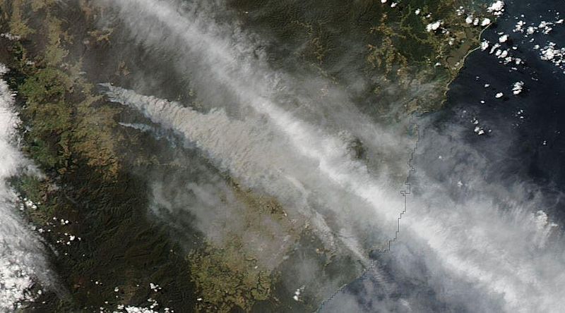
English: A view of the 2013 NSW Bushfires (specifically the State Mine, Mount Victoria and Linksview Road Fires) from the NASA Aqua Satellite using MOIDS Imagery. Captured on October 17, 2013. |
| Date | |
| Source | MODIS Rapid Response Cropped Image of A2013290035000-2013290035500 |
| Author | NASA |
| Camera location | | View this and other nearby images on: OpenStreetMap |
|---|
Licensing
| This file is in the public domain in the United States because it was solely created by NASA. NASA copyright policy states that "NASA material is not protected by copyright unless noted". (See Template:PD-USGov, NASA copyright policy page or JPL Image Use Policy.) | ||
 |
Warnings:
|
File history
Click on a date/time to view the file as it appeared at that time.
| Date/Time | Thumbnail | Dimensions | User | Comment | |
|---|---|---|---|---|---|
| current | 05:46, 19 October 2013 | | 945 × 525 (69 KB) | PhilipTerryGraham | User created page with UploadWizard |
File usage
The following pages on the English Wikipedia use this file (pages on other projects are not listed):
Global file usage
The following other wikis use this file:
- Usage on es.wikipedia.org
- Usage on sh.wikipedia.org
- Usage on www.wikidata.org