No higher resolution available.
NC-Congress-3.PNG (399 × 294 pixels, file size: 41 KB, MIME type: image/png)
| This is a file from the Wikimedia Commons. Information from its description page there is shown below. Commons is a freely licensed media file repository. You can help. |
Transwiki approved by: w:en:User:Dmcdevit
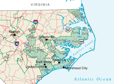
This image was copied from wikipedia:en. The original description was:
This map was obtained from an edition of the National Atlas of the United States. Like almost all works of the U.S. federal government, works from the National Atlas are in the public domain in the United States.
Online access: NationalAtlas.gov | 1970 print edition: Library of Congress, Perry-Castañeda Library
|
Map of North Carolina's 3nd Congressional district, adapted from http://nationalatlas.gov/congdistprint.html
w:en:Category:Congressional district maps of the 109th Congress
Original upload log
| date/time | username | resolution | size | edit summary |
|---|---|---|---|---|
| 01:34, 30 October 2004 | w:en:User:Seth Ilys | 399×294 | 41 KB | {{PD}}. Map of North Carolina's 2nd Congressional district, adapted from http://nationalatlas.gov/congdistprint.html |
Image description page history
| link | date/time | username | edit summary |
|---|---|---|---|
| http://en.wikipedia.org/w/index.php?title=Image:NC-Congress-3.PNG&redirect=no&oldid=27028026 | 07:06, 10 September 2007 | w:en:User:Dmcdevit | |
| http://en.wikipedia.org/w/index.php?title=Image:NC-Congress-3.PNG&redirect=no&oldid=27028026 | 01:40, 1 November 2005 | w:en:User:Markles | |
| http://en.wikipedia.org/w/index.php?title=Image:NC-Congress-3.PNG&redirect=no&oldid=27027784 | 01:37, 1 November 2005 | w:en:User:Markles | |
| http://en.wikipedia.org/w/index.php?title=Image:NC-Congress-3.PNG&redirect=no&oldid=16881998 | 01:00, 24 November 2004 | w:en:User:Neutrality | |
| http://en.wikipedia.org/w/index.php?title=Image:NC-Congress-3.PNG&redirect=no&oldid=7798114 | 01:41, 30 October 2004 | w:en:User:Seth Ilys | |
| http://en.wikipedia.org/w/index.php?title=Image:NC-Congress-3.PNG&redirect=no&oldid=6972177 | 01:34, 30 October 2004 | w:en:User:Seth Ilys | ({{PD}}. Map of North Carolina's 2nd Congressional district, adapted from http://nationalatlas.gov/congdistprint.html) |
File history
Click on a date/time to view the file as it appeared at that time.
| Date/Time | Thumbnail | Dimensions | User | Comment | |
|---|---|---|---|---|---|
| current | 16:00, 10 September 2007 | | 399 × 294 (41 KB) | BetacommandBot | Transwiki approved by: w:en:User:Dmcdevit This image was copied from wikipedia:en. The original description was: {{PD-USGov-Atlas}} Map of North Carolina's 3nd Congressional district, adapted from http://nationalatlas.gov/congdistprint.html [[w:en:C |
File usage
The following pages on the English Wikipedia use this file (pages on other projects are not listed):
Global file usage
The following other wikis use this file:
- Usage on simple.wikipedia.org