No higher resolution available.
NAVSPASUR_Fence_2001.jpg (550 × 433 pixels, file size: 82 KB, MIME type: image/jpeg)
| This is a file from the Wikimedia Commons. Information from its description page there is shown below. Commons is a freely licensed media file repository. You can help. |
Summary
| Description |
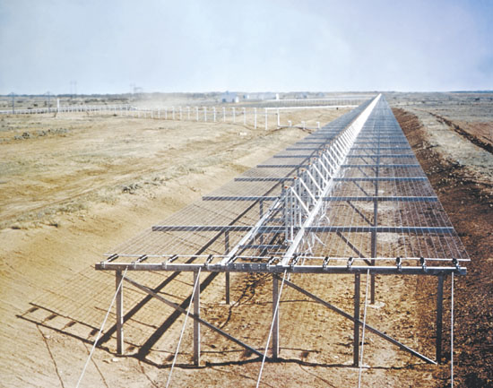
A two-mile array used to create part of the Air Force Space Surveillance System, aka Space Fence, with similar areas located throughout the southern United States. Source14a from Image gallery tp this article in the June 2001 issue of All Hands Magazine. |
| Source | Transferred from en.wikipedia to Commons. Transfer was stated to be made by User:Dual Freq. |
| Author |
Licensing
This file is a work of a sailor or employee of the U.S. Navy, taken or made as part of that person's official duties. As a work of the U.S. federal government, it is in the public domain in the United States.
|
 | |
| This file has been identified as being free of known restrictions under copyright law, including all related and neighboring rights. | ||
Original upload log
The original description page was here. All following user names refer to en.wikipedia.
- 2007-10-31 03:31 Dual Freq 550×433×8 (83511 bytes) full res version from http://www.mediacen.navy.mil/pubs/allhands/jun01/14a.jpg
- 2006-05-24 00:37 Dual Freq 164×129×8 (14925 bytes) ==Caption== A two-mile array used to create part of the [[Air Force Space Surveillance System]], aka Space Fence, with similar areas located throughout the southern United States. ==Source== http://www.mediacen.navy.mil/pubs/allhands/jun01/14asm.jpg from
File history
Click on a date/time to view the file as it appeared at that time.
| Date/Time | Thumbnail | Dimensions | User | Comment | |
|---|---|---|---|---|---|
| current | 03:35, 31 October 2007 | | 550 × 433 (82 KB) | Dual Freq | {{Information |Description=A two-mile array used to create part of the en:Air Force Space Surveillance System, aka Space Fence, with similar areas located throughout the southern United States. ==Source== [http://www.mediacen.navy.mil/pubs/allhands/ |
File usage
The following pages on the English Wikipedia use this file (pages on other projects are not listed):