
Size of this preview: 777 × 600 pixels. Other resolutions: 311 × 240 pixels | 622 × 480 pixels | 995 × 768 pixels | 1,280 × 988 pixels | 2,560 × 1,975 pixels | 3,674 × 2,835 pixels.
Original file (3,674 × 2,835 pixels, file size: 1.93 MB, MIME type: image/jpeg)
| This is a file from the Wikimedia Commons. Information from its description page there is shown below. Commons is a freely licensed media file repository. You can help. |
Summary
| Title |
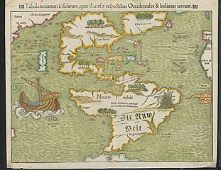
Latina: Tabula Novarum Insularum |
||||||||||||||||||||||||||
| Description |
English: Religion and politics are often closely allied, and this was especially the case in the sixteenth century. In this famous map, the Spanish flag flies prominently in the West Indies, while the Portuguese flag dominates the south Atlantic – reflecting pronouncements by Pope Alexander VI in 1493 and the Treaty of Tordesillas between Spain and Portugal of 1494. These declarations divided the non-Christian world between the two countries and charged the Portuguese and Spanish rulers with the responsibility of bringing the non-Christian inhabitants into the Catholic faith. This is reputedly the first printed map to name the Pacific Ocean and it is also among the earliest printed maps of the Western Hemisphere to show North and South America as separate but connected landmasses. The map’s creator, Münster, was a German Catholic Franciscan theologian and priest (ordained in 1512) as well as cartographer, cosmographer, humanist, mathematician, and scholar. |
||||||||||||||||||||||||||
| Date | |||||||||||||||||||||||||||
| Source | UTA Libraries Cartographic Connections: map / text | ||||||||||||||||||||||||||
| Creator |
|
||||||||||||||||||||||||||
| Credit line |
English: UTA Libraries Special Collections |
||||||||||||||||||||||||||
| Geotemporal data | |||||||||||||||||||||||||||
| Map location | Americas | ||||||||||||||||||||||||||
| Georeferencing | If inappropriate please set warp_status = skip to hide. | ||||||||||||||||||||||||||
| Bibliographic data | |||||||||||||||||||||||||||
| Publication |
Geographia Universalis |
||||||||||||||||||||||||||
| Author |
|
||||||||||||||||||||||||||
| Place of publication | Basel | ||||||||||||||||||||||||||
| Printed by |
|
||||||||||||||||||||||||||
| Archival data | |||||||||||||||||||||||||||
| Collection |
|
||||||||||||||||||||||||||
| Dimensions | height: 27.5 cm (10.8 in); width: 34.5 cm (13.5 in) | ||||||||||||||||||||||||||
| Medium | colored engraving on paper | ||||||||||||||||||||||||||
| artwork-references |
Burden The Mapping of North America, no. 12 , pp. 15−17 Martin and Martin Maps of Texas and the Southwest, 1513-1900, no. 2 , p. 67 |
||||||||||||||||||||||||||
.jpg)

Licensing

|
This file was provided to Wikimedia Commons by the University of Texas at Arlington Libraries as part of a cooperation project. The University of Texas at Arlington Libraries is part of the University of Texas at Arlington, a public research university located in Arlington, Texas.
|
|
The author died in 1552, so this work is in the public domain in its country of origin and other countries and areas where the copyright term is the author's life plus 100 years or fewer. This work is in the public domain in the United States because it was published (or registered with the U.S. Copyright Office) before January 1, 1929. | |
| This file has been identified as being free of known restrictions under copyright law, including all related and neighboring rights. | |
File history
Click on a date/time to view the file as it appeared at that time.
| Date/Time | Thumbnail | Dimensions | User | Comment | |
|---|---|---|---|---|---|
| current | 18:23, 29 January 2022 | | 3,674 × 2,835 (1.93 MB) | Michael Barera | == {{int:filedesc}} == {{Map |title = {{la|'''''Tabula Novarum Insularum'''''}} |description = {{en|Religion and politics are often closely allied, and this was especially the case in the sixteenth century. In this famous map, the Spanish flag flies prominently in the West Indies, while the Portuguese flag dominates the south Atlantic – reflecting pronouncements by Pope Alexander VI in 1493 and the Treaty of Tordesillas between Spain and Portugal of 1494. These declaration... |
File usage
The following pages on the English Wikipedia use this file (pages on other projects are not listed):
Global file usage
The following other wikis use this file:
- Usage on bg.wikipedia.org
- Usage on de.wikipedia.org
- Usage on el.wikipedia.org
- Usage on es.wikipedia.org
- Usage on eu.wikipedia.org
- Usage on fr.wikipedia.org
- Usage on it.wikipedia.org
- Usage on ru.wikipedia.org