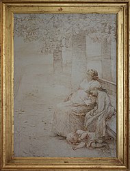
File:Marie Cazin - Les Oubliées.JPG

Original file(2,362 × 3,103 pixels, file size: 4.28 MB, MIME type: image/jpeg)

Marie Cazin: Les Oubliées  wikidata:Q23009006 reasonator:Q23009006
Artist
Marie Cazin  (1844–1924)  wikidata:Q3292434
 
Alternative names
Marie Guillet
Description French sculptor and painter
Date of birth/death 19 September 1844 Edit this at Wikidata 18 March 1924 Edit this at Wikidata
Location of birth/death Paimbœuf Équihen-Plage
Authority file
creator QS:P170,Q3292434
 Edit this at Wikidata
image of artwork listed in title parameter on this page
Title
Les Oubliées
label QS:Len,"Les Oubliées"
label QS:Lfr,"Les Oubliées"
label QS:Lnl,"Les Oubliées"
Object type painting Edit this at Wikidata
Genre genre art Edit this at Wikidata
Date 1890 Edit this at Wikidata
Medium oil on painting
Dimensions height: 183 cm (72 in); width: 132 cm (51.9 in)
dimensions QS:P2048,183U174728
dimensions QS:P2049,132U174728
institution QS:P195,Q2404549
Accession number
Notes Don Heseltine, 1925
References
Authority file
Source/Photographer Own work
Permission
(Reusing this file)
Public domain I, the copyright holder of this work, release this work into the public domain. This applies worldwide.
In some countries this may not be legally possible; if so:
I grant anyone the right to use this work for any purpose, without any conditions, unless such conditions are required by law.
Public domain

This work is in the public domain in its country of origin and other countries and areas where the copyright term is the author's life plus 80 years or fewer.


You must also include a United States public domain tag to indicate why this work is in the public domain in the United States. Note that a few countries have copyright terms longer than 80 years: Mexico has 100 years and Jamaica has 95 years. This image may not be in the public domain in these countries, which moreover do not implement the rule of the shorter term.

Camera location47° 23′ 42.66″ N, 0° 41′ 41.37″ E Kartographer map based on OpenStreetMap.View this and other nearby images on: OpenStreetMapinfo
Quality image
Quality image

Wikimedia Commons

This is a Quality image and is considered to meet the Quality image guidelines.

If you think this file should be featured on Wikimedia Commons as well, feel free to nominate it.
If you have an image of similar quality that can be published under a suitable copyright license, be sure to upload it, tag it, and nominate it.


This is a retouched picture, which means that it has been digitally altered from its original version. Modifications: geometry correction, levels and colours adjusted.

Captions

Add a one-line explanation of what this file represents

Items portrayed in this file

depicts

47°23'42.659"N, 0°41'41.370"E

File history

Click on a date/time to view the file as it appeared at that time.

Date/TimeThumbnailDimensionsUserComment
current21:10, 14 February 2011Thumbnail for version as of 21:10, 14 February 20112,362 × 3,103 (4.28 MB)Eusebius{{Information |Description ={{en|1=todo}} |Source ={{own}} |Author ={{User:Eusebius/Credits|cam=450D|lens=18-55|cat=tours}} |Date = |Permission = |other_versions = }}
The following pages on the English Wikipedia use this file (pages on other projects are not listed):

Global file usage

The following other wikis use this file:

Metadata