
Size of this preview: 800 × 380 pixels. Other resolutions: 320 × 152 pixels | 640 × 304 pixels | 1,024 × 487 pixels | 1,908 × 907 pixels.
Original file (1,908 × 907 pixels, file size: 735 KB, MIME type: image/jpeg)
| This is a file from the Wikimedia Commons. Information from its description page there is shown below. Commons is a freely licensed media file repository. You can help. |


Summary
| Description |
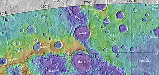
English: Topo map of Bond Crater and other features |
| Date | |
| Source | https://planetarynames.wr.usgs.gov/images/mc26_2014.pdf |
| Author | Jim Secosky modified NASA image NASA/USGS |
Licensing
| This file is in the public domain in the United States because it was solely created by NASA. NASA copyright policy states that "NASA material is not protected by copyright unless noted". (See Template:PD-USGov, NASA copyright policy page or JPL Image Use Policy.) | ||
 |
Warnings:
|
File history
Click on a date/time to view the file as it appeared at that time.
| Date/Time | Thumbnail | Dimensions | User | Comment | |
|---|---|---|---|---|---|
| current | 16:50, 30 January 2020 | | 1,908 × 907 (735 KB) | Jstuby | crop |
| 15:06, 23 July 2017 |  | 2,048 × 1,080 (753 KB) | Jimmarsmars | {{Information |Description ={{en|1=Topo map of Bond Crater and other features}} |Source =https://planetarynames.wr.usgs.gov/images/mc26_2014.pdf |Author =Jim Secosky modified NASA image NASA/USGS |Date =2017-07-23 |Permiss... |
File usage
The following pages on the English Wikipedia use this file (pages on other projects are not listed):
Global file usage
The following other wikis use this file:
- Usage on es.wikipedia.org
- Usage on fr.wikipedia.org
- Usage on it.wikipedia.org
- Usage on lt.wikipedia.org
- Usage on pt.wikipedia.org
- Usage on uk.wikipedia.org
- Usage on www.wikidata.org
- Usage on zh.wikipedia.org