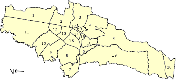
Mapa_administrativa_Bogota.png (600 × 279 pixels, file size: 48 KB, MIME type: image/png)
File history
Click on a date/time to view the file as it appeared at that time.
| Date/Time | Thumbnail | Dimensions | User | Comment | |
|---|---|---|---|---|---|
| current | 18:50, 24 May 2006 |  | 600 × 279 (48 KB) | Darina | == Beschreibung == {{Information| |Description=Administrative Gliederung von Bogotá, Kolumbien / Municipalities of Bogotá, Colombia / Localidades de Bogotá, Colombia. 1 - Usaquén, 2 - Chapinero, 3 - Santafé, 4- San Cristóbal, 5 - Usme, 6 - Tunjuel |
| 18:37, 24 May 2006 |  | 600 × 279 (47 KB) | Darina | == Beschreibung == {{Information| |Description=Administrative Gliederung von Bogotá, Kolumbien / Municipalities of Bogotá, Colombia / Localidades de Bogotá, Colombia. 1 - Usaquén, 2 - Chapinero, 3 - Santafé, 4- San Cristóbal, 5 - Usme, 6 - Tunjuel | |
| 18:24, 24 May 2006 |  | 600 × 279 (46 KB) | Darina | {{Information| |Description=Administrative Gliederung von Bogotá, Kolumbien / Municipalities of Bogotá, Colombia / Localidades de Bogotá, Colombia. 1 - Usaquén, 2 - Chapinero, 3 - Santafé, 4- San Cristóbal, 5 - Usme, 6 - Tunjuelito, 7 - Bosa, 8 - |
File usage
No pages on the English Wikipedia use this file (pages on other projects are not listed).
Global file usage
The following other wikis use this file:
- Usage on hr.wikipedia.org
- Usage on hu.wikipedia.org
- Usage on ms.wikipedia.org
- Bogotá
- Templat:Bogota DC
- Usaquén
- Chapinero
- Santa Fe (Bogotá)
- San Cristóbal (Bogotá)
- Usme
- Tunjuelito
- Bosa (Bogotá)
- Kennedy (Bogotá)
- Fontibon
- Engativá
- Suba (Bogotá)
- Barrios Unidos
- Teusaquillo
- Los Mártires
- Antonio Nariño (Bogotá)
- Puente Aranda
- La Candelaria
- Rafael Uribe Uribe (Bogotá)
- Ciudad Bolívar (Bogotá)
- Sumapaz (Bogotá)


