Size of this preview: 800 × 504 pixels. Other resolutions: 320 × 201 pixels | 640 × 403 pixels | 1,024 × 645 pixels | 1,280 × 806 pixels | 2,560 × 1,612 pixels | 5,379 × 3,387 pixels.
Original file (5,379 × 3,387 pixels, file size: 6.56 MB, MIME type: image/jpeg)
| This is a file from the Wikimedia Commons. Information from its description page there is shown below. Commons is a freely licensed media file repository. You can help. |
| Description |
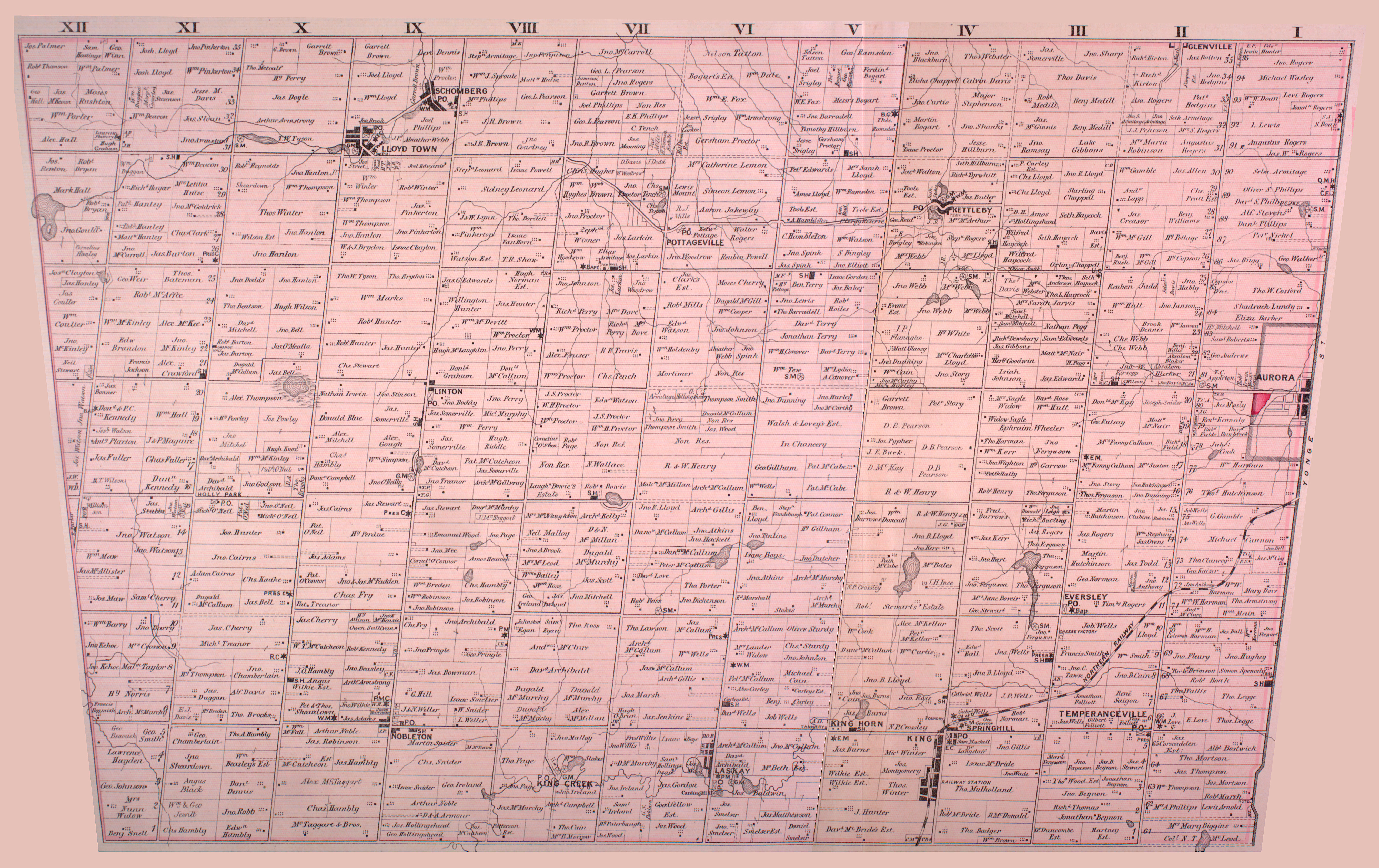
English: Map of Township of King (South), Ontario, part of York County, from 1878. Noted on the map are schoolhouses (SH), post offices (P.O.), Roman Catholic churches (R.C.), Baptist churches (Bap.), Presbyterian churches (PRES or PRESB), and other features. The map shows the boundaries for the township extending to Yonge Street; these lands, represented as lots 61-95, have since been ceded to the towns of Richmond Hill (southern portion), Aurora (central portion) and Newmarket (northern portion, most of which is not shown). |
| Date | |
| Source | http://digital.library.mcgill.ca/countyatlas/showtownship2.php?townshipid=King+South |
| Author | Miles & Co. |
| Other versions | The northern portion of the township is shown at File:Map of the Township of King, Ontario, northern portion, 1878.jpg |
This Canadian work is in the public domain in Canada because its copyright has expired due to one of the following:
it was not subject to Crown copyright, and
|
 |
File history
Click on a date/time to view the file as it appeared at that time.
| Date/Time | Thumbnail | Dimensions | User | Comment | |
|---|---|---|---|---|---|
| current | 16:35, 13 April 2009 | | 5,379 × 3,387 (6.56 MB) | Mindmatrix | {{Information |Description={{en|1=Map of Township of King South, Ontario, part of York County, from 1878. Noted on the map are schoolhouses (SH), post offices (P.O.), Roman Catholic churches (R.C.), Baptist churches (Bap.), Presbyterian churches (PRES or |
File usage
The following pages on the English Wikipedia use this file (pages on other projects are not listed):
Global file usage
The following other wikis use this file:
- Usage on zh.wikipedia.org