
Size of this preview: 800 × 564 pixels. Other resolutions: 320 × 226 pixels | 640 × 451 pixels | 990 × 698 pixels.
Original file (990 × 698 pixels, file size: 1.14 MB, MIME type: image/png)
| This is a file from the Wikimedia Commons. Information from its description page there is shown below. Commons is a freely licensed media file repository. You can help. |
Summary
| Description |
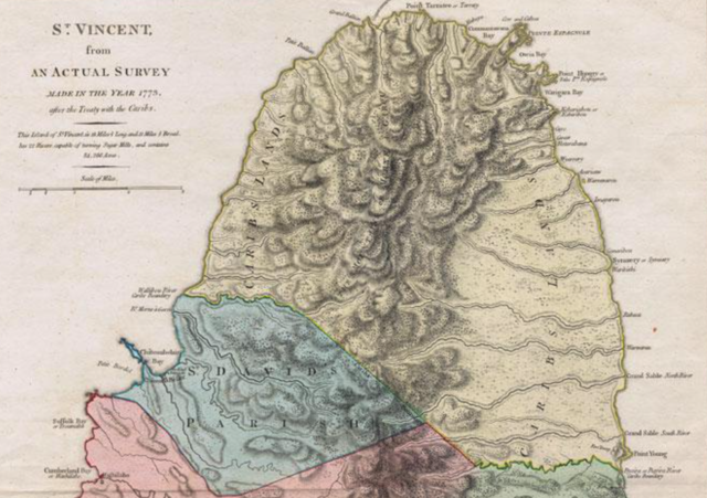
English: Section of tinted historic map of Saint Vincent |
| Date | |
| Source | https://www.abebooks.co.uk/servlet/BookDetailsPL?bi=30624712236&cm_mmc=ggl-_-UK_Shopp_RareStandard-_-product_id=bi%3A%2030624712236-_-keyword=&gclid=Cj0KCQiA0eOPBhCGARIsAFIwTs6Eox0hNXDKYxdCenJTNiAY9vn6CmFDlDE8mt6RDFP58wVtGhVay40aAmo5EALw_wcB |
| Author | Thomas Jeffreys |
Licensing
|
This work is in the public domain in its country of origin and other countries and areas where the copyright term is the author's life plus 70 years or fewer. This work is in the public domain in the United States because it was published (or registered with the U.S. Copyright Office) before January 1, 1929. | |
| This file has been identified as being free of known restrictions under copyright law, including all related and neighboring rights. | |
File history
Click on a date/time to view the file as it appeared at that time.
| Date/Time | Thumbnail | Dimensions | User | Comment | |
|---|---|---|---|---|---|
| current | 15:09, 2 February 2022 | | 990 × 698 (1.14 MB) | Leutha | Uploaded a work by Thomas Jeffreys from https://www.abebooks.co.uk/servlet/BookDetailsPL?bi=30624712236&cm_mmc=ggl-_-UK_Shopp_RareStandard-_-product_id=bi%3A%2030624712236-_-keyword=&gclid=Cj0KCQiA0eOPBhCGARIsAFIwTs6Eox0hNXDKYxdCenJTNiAY9vn6CmFDlDE8mt6RDFP58wVtGhVay40aAmo5EALw_wcB with UploadWizard |
File usage
The following pages on the English Wikipedia use this file (pages on other projects are not listed):
Global file usage
The following other wikis use this file:
- Usage on br.wikipedia.org
- Usage on fr.wikipedia.org