
Size of this preview: 790 × 599 pixels. Other resolutions: 317 × 240 pixels | 633 × 480 pixels | 1,013 × 768 pixels | 1,280 × 971 pixels | 2,560 × 1,942 pixels | 5,000 × 3,793 pixels.
Original file (5,000 × 3,793 pixels, file size: 3.81 MB, MIME type: image/jpeg)
| This is a file from the Wikimedia Commons. Information from its description page there is shown below. Commons is a freely licensed media file repository. You can help. |
Summary
| Description |
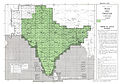
English: NI 44-9 Pangong Tso. Tile of the Map India and Pakistan 1:250,000. Series U502, U.S. Army Map Service, 1955 |
|||||||||
| Date |
Compiled: 1954 Revised: 1962 Printed: January 1963 |
|||||||||
| Source | Courtesy of the University of Texas Libraries, The University of Texas at Austin. ([1]) | |||||||||
| Creator |
English: U.S. Army Map Service |
|||||||||
| Geotemporal data | ||||||||||
| Bounding box |
|
|||||||||
| Georeferencing | ||||||||||
| Other versions |
|
|||||||||


-
 Index Map

![[1]](http://www.lib.utexas.edu/maps/ams/india/ni-44-09.jpg)
Licensing
This image or file is a work of a U.S. Army Corps of Engineers soldier or employee, taken or made as part of that person's official duties. As a work of the U.S. federal government, the image is in the public domain.
|
File history
Click on a date/time to view the file as it appeared at that time.
| Date/Time | Thumbnail | Dimensions | User | Comment | |
|---|---|---|---|---|---|
| current | 19:09, 11 September 2012 | | 5,000 × 3,793 (3.81 MB) | Slick-o-bot | {{Information |Description={{en|1=NI 44-9 Pangong Tso. Tile of the Map India and Pakistan 1:250,000. Series U502, U.S. Army Map Service, 1955}} |Source=https://www.lib.utexas.edu/maps/ams/india/ [http://www.lib.utexas.edu/maps/ams/india/ni-44-09.jpg] |... |
File usage
The following pages on the English Wikipedia use this file (pages on other projects are not listed):
Global file usage
The following other wikis use this file:
- Usage on bn.wikipedia.org
- Usage on hi.wikipedia.org
- Usage on mai.wikipedia.org
- Usage on ne.wikipedia.org