File:Map Hudson County NJ municipalities.gif

Map_Hudson_County_NJ_municipalities.gif(430 × 599 pixels, file size: 25 KB, MIME type: image/gif)

Summary

This locator map image could be re-created using vector graphics as an SVG file. This has several advantages; see Commons:Media for cleanup for more information. If an SVG form of this image is available, please upload it and afterwards replace this template with {{vector version available|new image name}}.


It is recommended to name the SVG file “Map Hudson County NJ municipalities.svg”—then the template Vector version available (or Vva) does not need the new image name parameter.
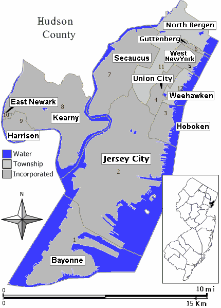
Description Closeup view of map of Hudson County, New Jersey (in style of map work by Jim Irwin, December 2005), with distance scale in miles/kilometers, Interstate-icons enlarged 50%, town names clarified, and side-edges limited (maximum width 430px < 600px helps readability).
Date
Source

Hand-edited like Wikimedia map: Image:Middletown twp nj 025.png (using gray town areas, with miles/kilometer scale, and road/icon colors).

References: County boundaries map: en:Image:Map Hudson County New Jersey municipalities.gif (from former User:JimIrwin).
Author Wikid77

Licensing

I, the copyright holder of this work, hereby publish it under the following license:
w:en:Creative Commons
attribution share alike
This file is licensed under the Creative Commons Attribution-Share Alike 3.0 Unported license. Subject to disclaimers.
You are free:
  • to share – to copy, distribute and transmit the work
  • to remix – to adapt the work
Under the following conditions:
  • attribution – You must give appropriate credit, provide a link to the license, and indicate if changes were made. You may do so in any reasonable manner, but not in any way that suggests the licensor endorses you or your use.
  • share alike – If you remix, transform, or build upon the material, you must distribute your contributions under the same or compatible license as the original.
This licensing tag was added to this file as part of the GFDL licensing update.
GNU head Permission is granted to copy, distribute and/or modify this document under the terms of the GNU Free Documentation License, Version 1.2 or any later version published by the Free Software Foundation; with no Invariant Sections, no Front-Cover Texts, and no Back-Cover Texts. A copy of the license is included in the section entitled GNU Free Documentation License. Subject to disclaimers.

Captions

Add a one-line explanation of what this file represents

Items portrayed in this file

depicts

21 August 2007

File history

Click on a date/time to view the file as it appeared at that time.

Date/TimeThumbnailDimensionsUserComment
current23:37, 21 August 2007Thumbnail for version as of 23:37, 21 August 2007430 × 599 (25 KB)Wikid77added forgotten name "West New York" on area #5
23:19, 21 August 2007Thumbnail for version as of 23:19, 21 August 2007430 × 599 (24 KB)Wikid77redrew entire map with detailed water-boundaries (actually more narrow 430px), with darker town names
17:21, 21 August 2007Thumbnail for version as of 17:21, 21 August 2007540 × 580 (21 KB)Wikid77{{Information | Description= Closeup view of map of Hudson County, New Jersey (in style of map work by Jim Irwin, December 2005), with distance scale in miles/kilometers, Interstate-icons enlarged 50%, town names clarifie
No pages on the English Wikipedia use this file (pages on other projects are not listed).