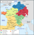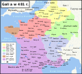
Size of this PNG preview of this SVG file: 577 × 599 pixels. Other resolutions: 231 × 240 pixels | 462 × 480 pixels | 740 × 768 pixels | 986 × 1,024 pixels | 1,972 × 2,048 pixels | 755 × 784 pixels.
Original file (SVG file, nominally 755 × 784 pixels, file size: 103 KB)
File history
Click on a date/time to view the file as it appeared at that time.
| Date/Time | Thumbnail | Dimensions | User | Comment | |
|---|---|---|---|---|---|
| current | 08:51, 4 September 2018 |  | 755 × 784 (103 KB) | Furfur | neuer Versuch |
| 08:40, 4 September 2018 |  | 755 × 784 (101 KB) | Furfur | Optik, Bildgröße | |
| 16:44, 22 November 2013 |  | 755 × 784 (596 KB) | Furfur | better color scheme | |
| 11:48, 29 November 2010 |  | 755 × 784 (592 KB) | Furfur | "Städt. Bischofssitz" in "Metropolitan-Bischofssitz" umgenannt. | |
| 09:15, 8 September 2010 |  | 755 × 784 (592 KB) | Furfur | Schriften in Konturen umgewandelt | |
| 09:12, 8 September 2010 |  | 755 × 784 (101 KB) | Furfur | Änderungen, entsprechend Diskussion ([http://de.wikipedia.org/wiki/Diskussion:Chlodwig_I.#Karte_Gallien_im_Jahr_481]). | |
| 12:56, 6 September 2010 |  | 755 × 784 (593 KB) | Furfur | Schriften in Konturen umgewandelt | |
| 08:39, 6 September 2010 |  | 755 × 784 (101 KB) | Furfur | Fehler beseitigt | |
| 08:33, 6 September 2010 |  | 755 × 784 (158 KB) | Furfur | {{Information |Description={{de|1=Territoriale Aufteilung Galliens in Jahr 481 n. Chr.}} {{fr|1=La division de la Gaule en 481.}} |Source=*File:La_division_de_la_Gaule_en_481.svg |Date=2010-09-06 08:32 (UTC) |Author=*[[:File:La_division_de_la_Gaule_ |
File usage
No pages on the English Wikipedia use this file (pages on other projects are not listed).
Global file usage
The following other wikis use this file:
- Usage on de.wikipedia.org
- Usage on ga.wikipedia.org
- Usage on rm.wikipedia.org
- Usage on www.wikidata.org


