Size of this preview: 514 × 600 pixels. Other resolutions: 206 × 240 pixels | 411 × 480 pixels | 658 × 768 pixels | 877 × 1,024 pixels | 1,486 × 1,734 pixels.
Original file (1,486 × 1,734 pixels, file size: 366 KB, MIME type: image/png)
File history
Click on a date/time to view the file as it appeared at that time.
| Date/Time | Thumbnail | Dimensions | User | Comment | |
|---|---|---|---|---|---|
| current | 06:49, 22 May 2008 |  | 1,486 × 1,734 (366 KB) | Amog | Resolved minor factual error |
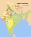
| 18:42, 21 May 2008 |  | 1,486 × 1,734 (367 KB) | Amog | {{Information |Description=A map on the major crop regions of India. |Source=self-made,using the India locator map and [http://www.lib.utexas.edu/maps/middle_east_and_asia/india_crop_1973.jpg] as reference. |Date |
File usage
The following 5 pages use this file:
Global file usage
The following other wikis use this file:
- Usage on ar.wikipedia.org
- Usage on de.wikipedia.org
- Usage on es.wikibooks.org
- Usage on hi.wikipedia.org
- Usage on hi.wikibooks.org
- Usage on hu.wikipedia.org
- Usage on id.wikipedia.org
- Usage on ja.wikipedia.org
- Usage on ka.wikipedia.org
- Usage on kn.wikipedia.org
- Usage on mn.wikipedia.org
- Usage on pa.wikipedia.org
- Usage on sa.wikipedia.org
- Usage on sl.wikipedia.org
- Usage on sv.wikipedia.org
- Usage on ta.wikipedia.org