
Size of this preview: 382 × 599 pixels. Other resolutions: 153 × 240 pixels | 306 × 480 pixels | 490 × 768 pixels | 653 × 1,024 pixels | 2,062 × 3,231 pixels.
Original file (2,062 × 3,231 pixels, file size: 2.7 MB, MIME type: image/jpeg)
| This is a file from the Wikimedia Commons. Information from its description page there is shown below. Commons is a freely licensed media file repository. You can help. |
 This media file has been nominated for deletion since 25 June 2024. To discuss it, please visit the nomination page.
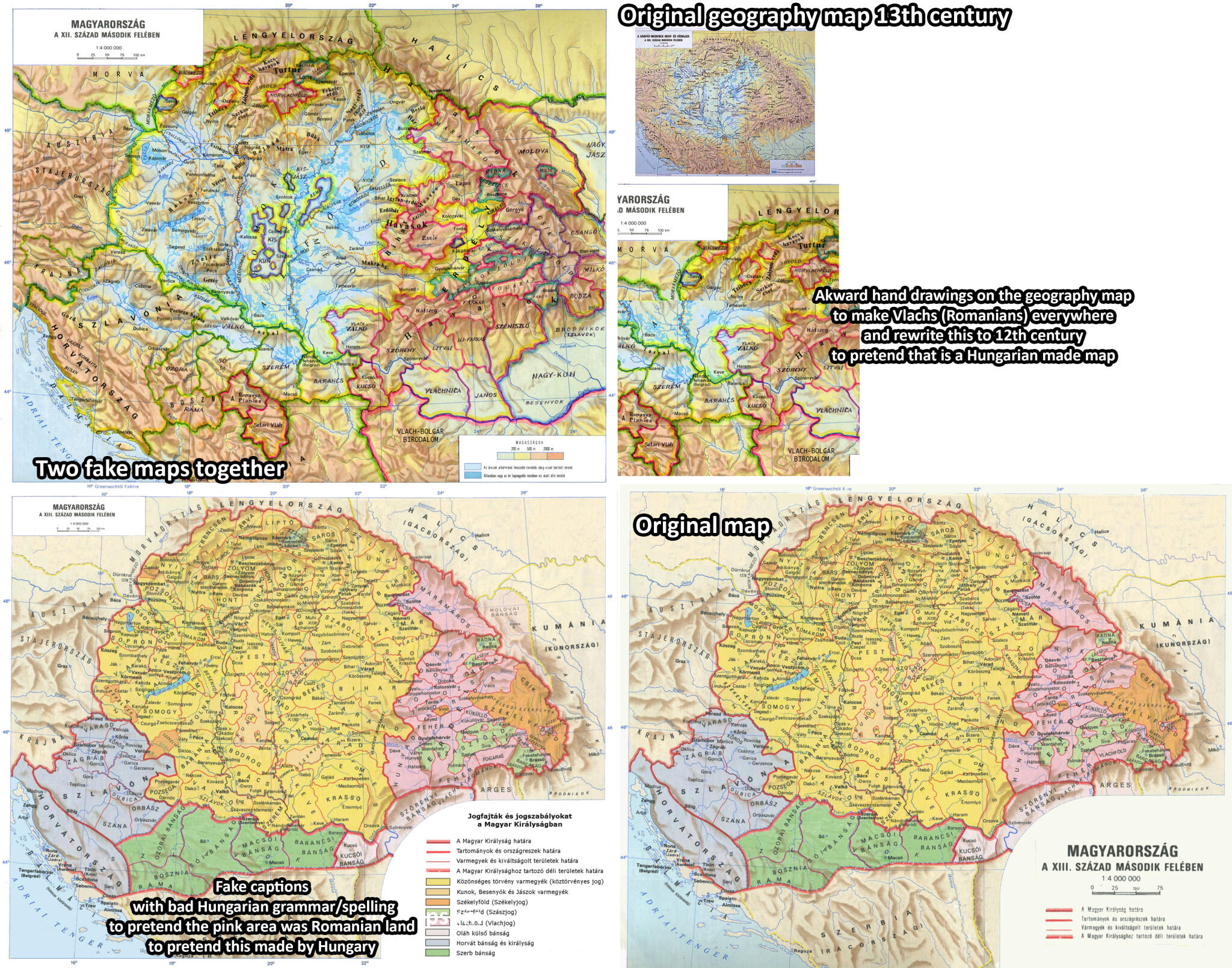
Do not remove this tag until the deletion nomination is closed. Reason for the nomination: That is a falsified original Hungarian map by Romanian nationalist purpose to spread to articles. It is not nice to change original academic maps. Very unprofessional to put together an obvious hand drawed upper map with an another one. The upper map is original a hidrography map from 13th century where the falsifier hand painted colored circles and claimed that is 12th century. The lower map the falsifier rewrote the infobox claiming the pink areas were Romanian areas, however the original map does not say that. It is also obvious for a Hungarian reader that map made by a bad Hungarian grammar, so the falsifier dont know Hungarian language but by bad faith he wanted to pretend that map made by Hungarian academy. Original maps and explanation here: https://cdn.imgpile.com/f/ZQ9mvib_xl.jpg
| |||
| |||
Summary
| Description |
Français : Hungary 12th 13th Centuries |
||
| Date | |||
| Source | Synthesis of Unger, Matyas (dir.): Történelmi atlasz a középiskolák számára, Kartográfiai Vállalat Szerkesztőbizottsága, Budapest 1989 ISBN 963-351-422-3 enriched following Mihályi, János Magyar diplomák a XIII és XIV századbol; Sándor Márki (dead 1925) & József Bokor (dead 1917), A Pallas nagy lexikona; Czamańska, Ilona: The Vlachs – several research problems, Balcanica Posnaniensia - Acta et studia n° 22, february 2015, 1, pp. 7–16; Thurocz: Chronica Hungarorum, 1486, in A. Drăgoescu (éd.) Transilvania, istoria României, 2 vol., Cluj, 1997-99; Ovid Sachelarie, Nicolae Stoicescu (dir.): Instituţii feudale din ţările române, Romanian Academy Press, Bucharest 1988; Alexandru Avram, Mircea Babeş, Lucian Badea, Mircea Petrescu-Dîmboviţa & Alexandru Vulpe (dir.): Istoria românilor : moştenirea timpurilor îndepărtate, vol.1, Editura Enciclopedică, Bucharest 2001, ISBN 973-45-0382-0. | ||
| Author | Qualimac | ||
| Permission (Reusing this file) |
|
Licensing
I, the copyright holder of this work, hereby publish it under the following license:
This file is licensed under the Creative Commons Attribution-Share Alike 4.0 International license.
- You are free:
- to share – to copy, distribute and transmit the work
- to remix – to adapt the work
- Under the following conditions:
- attribution – You must give appropriate credit, provide a link to the license, and indicate if changes were made. You may do so in any reasonable manner, but not in any way that suggests the licensor endorses you or your use.
- share alike – If you remix, transform, or build upon the material, you must distribute your contributions under the same or compatible license as the original.
File history
Click on a date/time to view the file as it appeared at that time.
| Date/Time | Thumbnail | Dimensions | User | Comment | |
|---|---|---|---|---|---|
| current | 11:36, 29 August 2023 | | 2,062 × 3,231 (2.7 MB) | Qualimac | Uploaded own work with UploadWizard |
File usage
The following pages on the English Wikipedia use this file (pages on other projects are not listed):