.jpg)
.jpg&action=edit&redlink=1)

Original file (1,266 × 779 pixels, file size: 218 KB, MIME type: image/jpeg)
| This is a file from the Wikimedia Commons. Information from its description page there is shown below. Commons is a freely licensed media file repository. You can help. |
.jpg)
| Description |
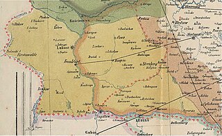
English: Part of a historical map of Greater Poland (Middle Ages) made by Dr. T. Szulc and included in the 4th volume of Codex diplomaticus Maioris Poloniae, covering a Lubusz Land and land given up to Silesian dukes by the Greatpoland dukes Polski: Fragment historycznej mapy Wielkopolski w epoce piastowskiej wykonanej przez Dr. T. Szulca i zamieszczonej w czwartym tomie Kodeksu dyplomatycznego Wielkopolski, obrazujący Ziemię Lubuską (granice diecezji lubuskiej) oraz obszar odstąpiony książętom śląskim przez książąt wielkopolskich |
| Date | (UTC) |
| Source | |
| Author |
|
| This is a retouched picture, which means that it has been digitally altered from its original version. Modifications: Extracting part of the map to cover Lubusz Land. The original can be viewed here: WielkoPolska epoki Piastowskiej.jpg:
|
|
This work is in the public domain in its country of origin and other countries and areas where the copyright term is the author's life plus 70 years or fewer.
| |
| This file has been identified as being free of known restrictions under copyright law, including all related and neighboring rights. | |
Original upload log
This image is a derivative work of the following images:
- File:WielkoPolska_epoki_Piastowskiej.jpg licensed with PD-old
- 2009-06-22T15:28:59Z Paelius 4075x3613 (10969409 Bytes) {{Information |Description={{en|1=Historical map of Greater Poland (Middle Ages) made by Dr. T. Szulc and included in the 4th volume of Codex diplomaticus Maioris Poloniae}} {{pl|1=Historyczna mapa Wielkopolski w epoce piasto
Uploaded with derivativeFX
File history
Click on a date/time to view the file as it appeared at that time.
| Date/Time | Thumbnail | Dimensions | User | Comment | |
|---|---|---|---|---|---|
| current | 12:32, 14 January 2022 | | 1,266 × 779 (218 KB) | Davey2010 | rv vandal - please seek consensus for your changes |
| 19:13, 13 January 2022 |  | 1,023 × 1,056 (362 KB) | LechitaPL | Reverted to version as of 20:25, 19 September 2021 (UTC) (vandalized) | |
| 01:23, 13 January 2022 |  | 1,266 × 779 (218 KB) | Davey2010 | Reverted to version as of 12:21, 19 August 2009 (UTC) | |
| 20:25, 19 September 2021 |  | 1,023 × 1,056 (362 KB) | LechitaPL | Zmiany | |
| 12:21, 19 August 2009 |  | 1,266 × 779 (218 KB) | Opole.pl | {{Information |Description={{en|1=Part of a historical map of Greater Poland (Middle Ages) made by Dr. T. Szulc and included in the 4th volume of Codex diplomaticus Maioris Poloniae, covering Lubusz Land}} {{pl|1=Fragment historycznej mapy Wielkopolski w |
File usage
Global file usage
The following other wikis use this file:
- Usage on ar.wikipedia.org
- Usage on fr.wikipedia.org
- Usage on ru.wikipedia.org
.jpg)