No higher resolution available.
Lossiemouth_Aerial_Shot_-_geograph.org.uk_-_936815.jpg (640 × 480 pixels, file size: 75 KB, MIME type: image/jpeg)
| This is a file from the Wikimedia Commons. Information from its description page there is shown below. Commons is a freely licensed media file repository. You can help. |
Summary
| Description |
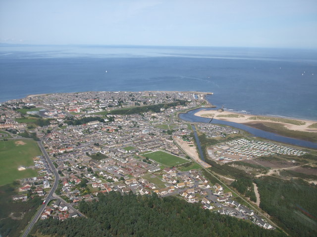
English: Lossiemouth Aerial Shot A photograph of the Beautiful seaside town of Lossiemouth on the Moray Coast, taken from a Grob Tutor Light Aircraft high in the sky just South of the town. Pictured is the majority of the town itself, the fantastic East Beach, The harbour and The Moray Firth. |
| Date | |
| Source | From geograph.org.uk |
| Author | Craig Williams |
| Attribution (required by the license) | Craig Williams / Lossiemouth Aerial Shot / |
| Camera location | | View this and other nearby images on: OpenStreetMap |
|---|
_heading:22.00&language=en)
| Object location | | View this and other nearby images on: OpenStreetMap |
|---|
_heading:22.00&language=en)
Licensing

|
This image was taken from the Geograph project collection. See this photograph's page on the Geograph website for the photographer's contact details. The copyright on this image is owned by Craig Williams and is licensed for reuse under the Creative Commons Attribution-ShareAlike 2.0 license.
|
This file is licensed under the Creative Commons Attribution-Share Alike 2.0 Generic license.
Attribution: Craig Williams
- You are free:
- to share – to copy, distribute and transmit the work
- to remix – to adapt the work
- Under the following conditions:
- attribution – You must give appropriate credit, provide a link to the license, and indicate if changes were made. You may do so in any reasonable manner, but not in any way that suggests the licensor endorses you or your use.
- share alike – If you remix, transform, or build upon the material, you must distribute your contributions under the same or compatible license as the original.

|
The categories of this image need checking. You can do so here.
|
File history
Click on a date/time to view the file as it appeared at that time.
| Date/Time | Thumbnail | Dimensions | User | Comment | |
|---|---|---|---|---|---|
| current | 06:56, 22 February 2011 | | 640 × 480 (75 KB) | GeographBot | == {{int:filedesc}} == {{Information |description={{en|1=Lossiemouth Aerial Shot A photograph of the Beautiful seaside town of Lossiemouth on the Moray Coast, taken from a Grob Tutor Light Aircraft high in the sky just South of the town. Pictured is the m |
File usage
The following pages on the English Wikipedia use this file (pages on other projects are not listed):
Global file usage
The following other wikis use this file:
- Usage on ceb.wikipedia.org
- Usage on cy.wikipedia.org
- Usage on en.wikivoyage.org
- Usage on es.wikipedia.org
- Usage on et.wikipedia.org
- Usage on eu.wikipedia.org
- Usage on fa.wikipedia.org
- Usage on fr.wikipedia.org
- Usage on ga.wikipedia.org
- Usage on it.wikivoyage.org
- Usage on nl.wikipedia.org
- Usage on no.wikipedia.org
- Usage on sco.wikipedia.org
- Usage on www.wikidata.org