Size of this preview: 694 × 600 pixels. Other resolutions: 278 × 240 pixels | 555 × 480 pixels | 889 × 768 pixels | 1,185 × 1,024 pixels | 1,357 × 1,173 pixels.
Original file (1,357 × 1,173 pixels, file size: 983 KB, MIME type: image/jpeg)
| This is a file from the Wikimedia Commons. Information from its description page there is shown below. Commons is a freely licensed media file repository. You can help. |
Summary
| Title |
English: Mexico & Guatimala [sic] |
||||||||||||||||||||||||||
| Description |
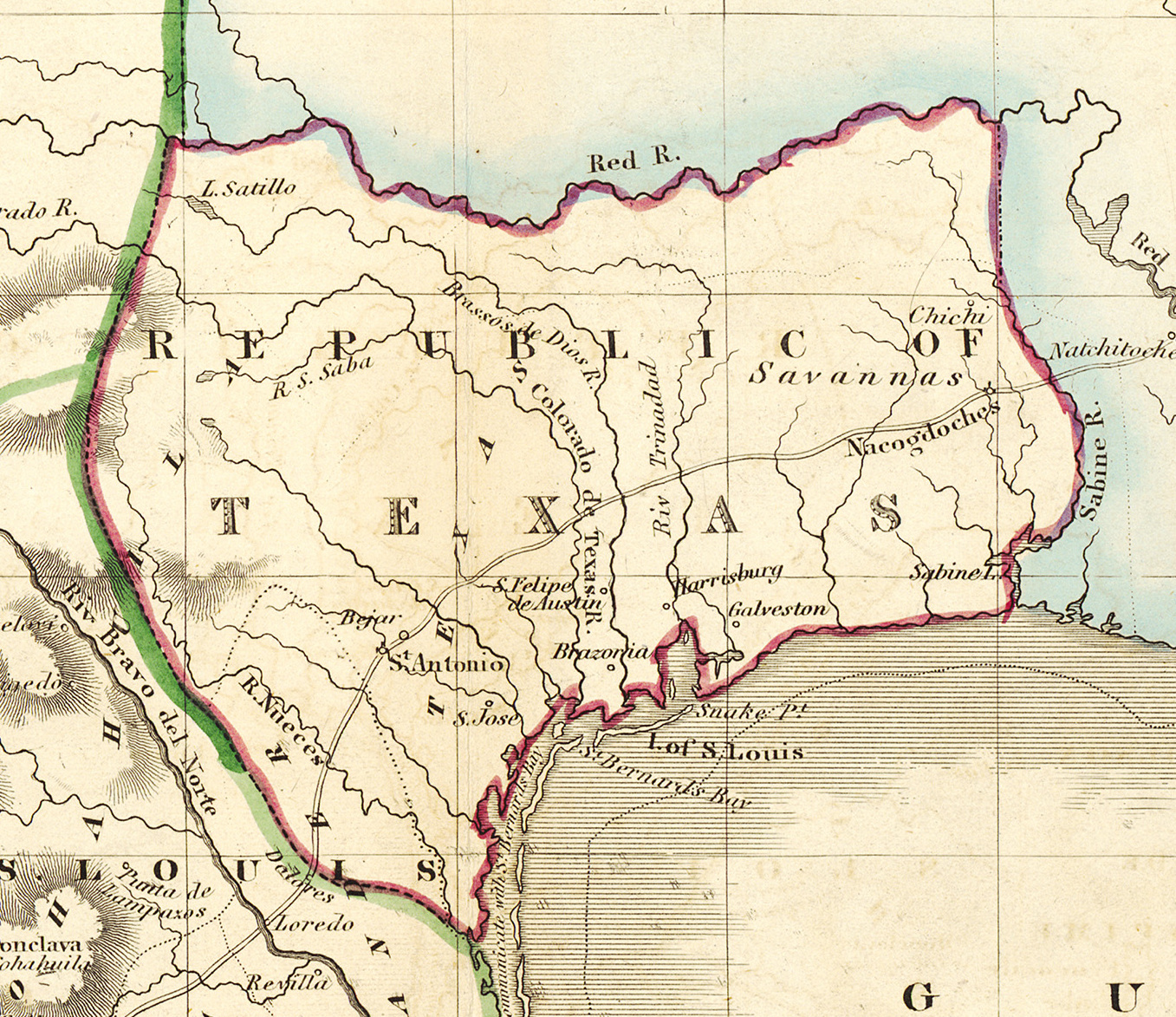
English: Shortly after Texas declared its independence from Mexico in 1836, the Edinburgh painter, engraver, printer, cartographer, lithographer, and publisher William Home Lizars (1788-1859), brother of Daniel Lizars II (1793-1875), updated the original plate for the map of Mexico & Guatemala to include the new republic. He added the towns of Galveston, Harrisburg, Brazoria, S. Felipe de Austin (although recently destroyed), Bejar, and "S. Jose" (probably intended to represent Goliad). Lizars made no further improvements to the general cartographic shape of the republic except to show the Nueces River as the southern boundary and the western boundary curving to the point where the 100th meridian strikes the Red River. The map continues to show Mexico's administrative districts as Spanish Intendencies (Intendencias) and Internal Provinces (Provincias Internas) over fifteen years since Mexico's independence. |
||||||||||||||||||||||||||
| Date | circa 1836 | ||||||||||||||||||||||||||
| Source | UTA Libraries Cartographic Connections: map / text | ||||||||||||||||||||||||||
| Creator |
|
||||||||||||||||||||||||||
| Credit line |
English: The University of Texas at Arlington Libraries Special Collections, Gift of Lewis & Virginia Buttery |
||||||||||||||||||||||||||
| Geotemporal data | |||||||||||||||||||||||||||
| Map location | Texas | ||||||||||||||||||||||||||
| Georeferencing | If inappropriate please set warp_status = skip to hide. | ||||||||||||||||||||||||||
| Bibliographic data | |||||||||||||||||||||||||||
| Place of publication | Edinburgh | ||||||||||||||||||||||||||
| Publisher |
|
||||||||||||||||||||||||||
| Archival data | |||||||||||||||||||||||||||
| Collection |
|
||||||||||||||||||||||||||
| Dimensions | height: 42 cm (16.5 in); width: 51.5 cm (20.2 in) | ||||||||||||||||||||||||||
| Medium | colored engraving on paper | ||||||||||||||||||||||||||
| artwork-references |
Worms, Laurence; Ashley Baynton-Williams (2011) British Map Engravers, London: Rare Book Society, pp. 406–409 |
||||||||||||||||||||||||||
| Other versions | |||||||||||||||||||||||||||

.jpg)
.jpg&action=edit&redlink=1)
.jpg)
Licensing

|
This file was provided to Wikimedia Commons by the University of Texas at Arlington Libraries as part of a cooperation project. The University of Texas at Arlington Libraries is part of the University of Texas at Arlington, a public research university located in Arlington, Texas.
|
|
The author died in 1859, so this work is in the public domain in its country of origin and other countries and areas where the copyright term is the author's life plus 100 years or fewer. This work is in the public domain in the United States because it was published (or registered with the U.S. Copyright Office) before January 1, 1929. | |
| This file has been identified as being free of known restrictions under copyright law, including all related and neighboring rights. | |
File history
Click on a date/time to view the file as it appeared at that time.
| Date/Time | Thumbnail | Dimensions | User | Comment | |
|---|---|---|---|---|---|
| current | 15:18, 13 July 2019 | | 1,357 × 1,173 (983 KB) | Michael Barera | File:Lizars Mexico & Guatimala 1836 UTA.jpg cropped 79 % horizontally, 78 % vertically using CropTool with precise mode. |
File usage
The following pages on the English Wikipedia use this file (pages on other projects are not listed):
Global file usage
The following other wikis use this file:
- Usage on azb.wikipedia.org
- Usage on ca.wikipedia.org
- Usage on cv.wikipedia.org
- Usage on eo.wikipedia.org
- Usage on fa.wikipedia.org
- Usage on it.wikipedia.org
- Usage on ja.wikipedia.org
- Usage on ko.wikipedia.org
- Usage on mk.wikipedia.org
- Usage on mzn.wikipedia.org
- Usage on pl.wikipedia.org
- Usage on pt.wikipedia.org
- Usage on sv.wikipedia.org
- Usage on th.wikipedia.org
- Usage on yi.wikipedia.org
- Usage on zh-min-nan.wikipedia.org
.jpg)