
Size of this preview: 715 × 599 pixels. Other resolutions: 286 × 240 pixels | 573 × 480 pixels | 916 × 768 pixels | 1,222 × 1,024 pixels | 2,044 × 1,713 pixels.
Original file (2,044 × 1,713 pixels, file size: 2.83 MB, MIME type: image/jpeg)
| This is a file from the Wikimedia Commons. Information from its description page there is shown below. Commons is a freely licensed media file repository. You can help. |
Summary
| Description |
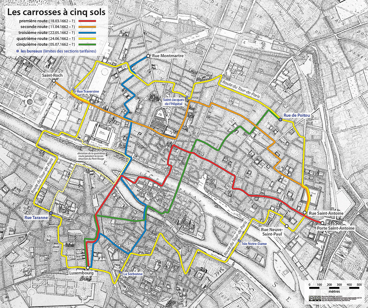
Deutsch: Die Linienführungen der carrosses à cinq sols Français : Plan des lignes des carrosses à cinq sols, transposés sur le plan de Paris de Jouvin de Rochefort de 1672 |
|||
| Date | (see file history) | |||
| Source |
Own work, using:
|
|||
| Author | Chumwa | |||
| Permission (Reusing this file) |
I, the copyright holder of this work, hereby publish it under the following license: This file is licensed under the Creative Commons Attribution-Share Alike 2.5 Generic license.
Sie dürfen das Bild zu den folgenden Bedingungen nutzen:
|
|||
| Other versions |
|
File history
Click on a date/time to view the file as it appeared at that time.
| Date/Time | Thumbnail | Dimensions | User | Comment | |
|---|---|---|---|---|---|
| current | 18:45, 9 April 2013 | | 2,044 × 1,713 (2.83 MB) | Chumwa | deviation of the ''cinquième route'' during the reconstruction of Pont Rouge added |
| 20:05, 8 April 2013 |  | 2,044 × 1,713 (2.82 MB) | Chumwa | corr | |
| 21:15, 4 April 2013 |  | 2,680 × 2,244 (4.61 MB) | Chumwa | corr | |
| 18:33, 3 April 2013 |  | 2,680 × 2,244 (4.62 MB) | Chumwa | correction of the cinquième route | |
| 21:45, 2 April 2013 |  | 2,680 × 2,244 (4.62 MB) | Chumwa | added the "bureaux" | |
| 21:36, 1 April 2013 |  | 2,680 × 2,244 (4.62 MB) | Chumwa | as RGB | |
| 21:28, 1 April 2013 |  | 2,680 × 2,244 (13.37 MB) | Chumwa | corr | |
| 19:42, 1 April 2013 |  | 2,680 × 2,244 (3.8 MB) | Chumwa | =={{int:filedesc}}== {{Information |description={{de|1=Die Linienführungen der ''Les carrosses à cinq sols''}} |date=(see file history) |source={{own}}, using: * background map: Paris map by Jouvin de Rochefo... |
File usage
The following pages on the English Wikipedia use this file (pages on other projects are not listed):
Global file usage
The following other wikis use this file:
- Usage on de.wikipedia.org
- Usage on fr.wikipedia.org
- Carrosse à cinq sols
- Discussion:Carrosse à cinq sols
- Wikipédia:Statistiques des anecdotes de la page d'accueil/Visibilité des anecdotes (2019)
- Discussion:Carrosses à cinq sols/LSV 16752
- Wikipédia:Statistiques des anecdotes de la page d'accueil/Visibilité des anecdotes (2019)/2019 06
- Projet:Aide et accueil/Twitter/Tweets/archives/juin 2019
- Wikipédia:Le saviez-vous ?/Archives/2019
- Discussion:Carrosses à cinq sols/LSV 18290
- Usage on ja.wikipedia.org
- Usage on no.wikipedia.org
- Usage on pl.wikipedia.org
- Usage on sv.wikipedia.org
- Usage on www.wikidata.org