File:Allentown-Bethlehem-Easton metropolitan area map.png

Allentown-Bethlehem-Easton_metropolitan_area_map.png(500 × 500 pixels, file size: 51 KB, MIME type: image/png)

Summary

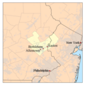
Description This is a map of the Allentown-Bethlehem-Easton metropolitan area I made using U.S. Census Bureau data. The Metropolitan Statistical Area is shown in yellow. The light gray shading indicates urbanized areas.
Date 3 January 2007 (original upload date)
Source No machine-readable source provided. Own work assumed (based on copyright claims).
Author No machine-readable author provided. Kmusser assumed (based on copyright claims).

Licensing

I, the copyright holder of this work, hereby publish it under the following license:
w:en:Creative Commons
attribution share alike
This file is licensed under the Creative Commons Attribution-Share Alike 2.5 Generic license.
You are free:
  • to share – to copy, distribute and transmit the work
  • to remix – to adapt the work
Under the following conditions:
  • attribution – You must give appropriate credit, provide a link to the license, and indicate if changes were made. You may do so in any reasonable manner, but not in any way that suggests the licensor endorses you or your use.
  • share alike – If you remix, transform, or build upon the material, you must distribute your contributions under the same or compatible license as the original.

Captions

Add a one-line explanation of what this file represents

Items portrayed in this file

depicts

3 January 2007

image/png

fe9ed7b054e5053c18f5180456eee7821baa6c07

52,388 byte

500 pixel

500 pixel

File history

Click on a date/time to view the file as it appeared at that time.

Date/TimeThumbnailDimensionsUserComment
current23:59, 9 February 2010Thumbnail for version as of 23:59, 9 February 2010500 × 500 (51 KB)Yassieadded location of Philadelphia and New York City for better understanding of relative location of Lehigh Valley.
20:22, 3 January 2007Thumbnail for version as of 20:22, 3 January 2007500 × 500 (46 KB)Kmusser
19:48, 3 January 2007Thumbnail for version as of 19:48, 3 January 2007500 × 500 (45 KB)Kmusser
19:47, 3 January 2007Thumbnail for version as of 19:47, 3 January 2007300 × 300 (22 KB)Kmusser
19:46, 3 January 2007Thumbnail for version as of 19:46, 3 January 2007500 × 500 (189 KB)Kmusser== Summary == This is a map of the Lehigh Valley Metro area I made using U.S. Census Bureau data. The Metropolitan Statistical Area is shown in yellow. The light gr
The following pages on the English Wikipedia use this file (pages on other projects are not listed):

Global file usage

The following other wikis use this file: