
Size of this preview: 800 × 586 pixels. Other resolutions: 320 × 234 pixels | 640 × 469 pixels | 1,024 × 750 pixels | 1,280 × 937 pixels | 2,325 × 1,702 pixels.
Original file (2,325 × 1,702 pixels, file size: 3.81 MB, MIME type: image/jpeg)
| This is a file from the Wikimedia Commons. Information from its description page there is shown below. Commons is a freely licensed media file repository. You can help. |
Summary
| Description |
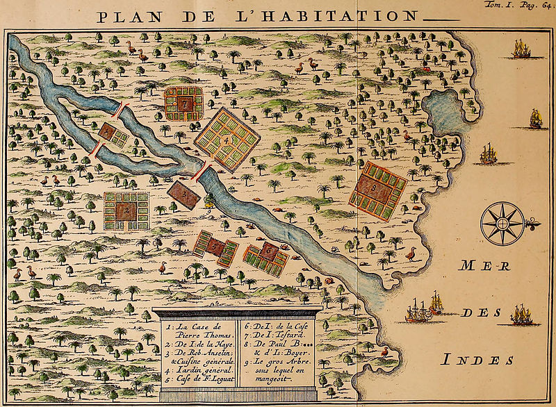
English: François Leguat's map of his settlement on Rodrigues. Rodrigues Solitaires can be seen sprinkled all over the map.
Français : Carte de l'établissement de François Leguat, 1708. Des drontes de Rodrigues y sont représentés. |
| Date | |
| Source |
http://www.crommelin.org/history/Ancestors/JeanTestart/JeanTestart.htm Scanned from: Leguat, François (1708) Voyage et avantures de François Leguat & de ses compagnons en deux isles desertes des Indes Orientales. (Volume 1) Amsterdam: J.-L. de Lorme, p. 64. |
| Author | François Leguat |
Licensing
|
This work is in the public domain in its country of origin and other countries and areas where the copyright term is the author's life plus 100 years or fewer. This work is in the public domain in the United States because it was published (or registered with the U.S. Copyright Office) before January 1, 1929. | |
| This file has been identified as being free of known restrictions under copyright law, including all related and neighboring rights. | |
File history
Click on a date/time to view the file as it appeared at that time.
| Date/Time | Thumbnail | Dimensions | User | Comment | |
|---|---|---|---|---|---|
| current | 11:45, 29 July 2012 | | 2,325 × 1,702 (3.81 MB) | FunkMonk | |
| 02:40, 4 December 2011 |  | 2,437 × 1,889 (1,015 KB) | FunkMonk | {{Information |Description=François Leguat's map of his settlement on Rodrigues. Rodrigues Solitairies can be seen sprinkled all over the map. |Source=http://www.crommelin.org/history/Ancestors/JeanTestart/JeanTestart.htm |Date=1708 |Author=François Leg |
File usage
The following pages on the English Wikipedia use this file (pages on other projects are not listed):
Global file usage
The following other wikis use this file:
- Usage on ar.wikipedia.org
- Usage on ca.wikipedia.org
- Usage on es.wikipedia.org
- Usage on fr.wikipedia.org
- Usage on pl.wikipedia.org
- Usage on pt.wikipedia.org