
Size of this preview: 800 × 593 pixels. Other resolutions: 320 × 237 pixels | 640 × 474 pixels | 1,024 × 758 pixels | 1,280 × 948 pixels.
Original file (1,280 × 948 pixels, file size: 223 KB, MIME type: image/jpeg)
| This is a file from the Wikimedia Commons. Information from its description page there is shown below. Commons is a freely licensed media file repository. You can help. |
Summary
| Description |
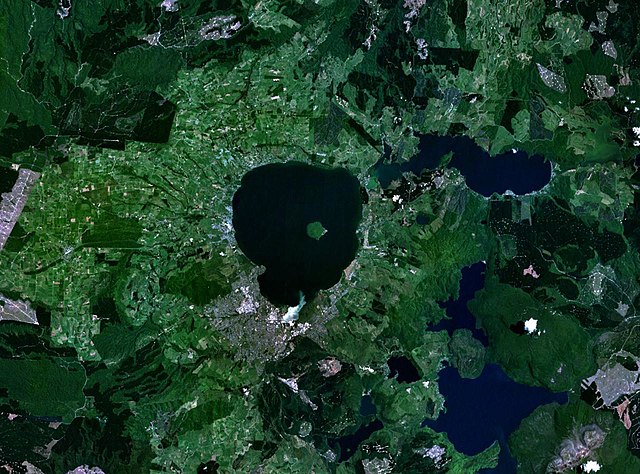
English: en:NASA World Wind false-colour landsat-7 composite satellite photo of en:Lake Rotorua in en:New Zealand. en:Category:Taupo Volcanic Zone |
| Source | en:NASA World Wind |
| Author | en:NASA World Wind |
Licensing
| This image is in the public domain because it is a screenshot from NASA’s globe software World Wind using a public domain layer, such as Blue Marble, MODIS, Landsat, SRTM, USGS or GLOBE.
|
 |
Original upload log
The original description page was here. All following user names refer to en.wikipedia.
- 2005-03-27 02:00 John Fader 1280×948×8 (227865 bytes) [[NASA World Wind]] false-colour landsat-7 composite satellite photo of [[Lake Rotorua]] in [[New Zealand]]. {{PD-USGov-NASA}}
File history
Click on a date/time to view the file as it appeared at that time.
| Date/Time | Thumbnail | Dimensions | User | Comment | |
|---|---|---|---|---|---|
| current | 16:16, 3 January 2008 | | 1,280 × 948 (223 KB) | Rémih | {{Information |Description={{en|en:NASA World Wind false-colour landsat-7 composite satellite photo of en:Lake Rotorua in en:New Zealand. en:Category:Taupo Volcanic Zone}} |Source=Transfered from [http://en.wikipedia.org en.wikipedia] |
File usage
The following pages on the English Wikipedia use this file (pages on other projects are not listed):
Global file usage
The following other wikis use this file:
- Usage on an.wikipedia.org
- Usage on ar.wikipedia.org
- Usage on arz.wikipedia.org
- Usage on ceb.wikipedia.org
- Usage on de.wikipedia.org
- Usage on el.wikipedia.org
- Usage on eo.wikipedia.org
- Usage on fr.wikipedia.org
- Usage on it.wikipedia.org
- Usage on ja.wikipedia.org
- Usage on ko.wikipedia.org
- Usage on no.wikipedia.org
- Usage on pl.wikipedia.org
- Usage on ru.wikipedia.org
- Usage on sk.wikipedia.org
- Usage on sl.wikipedia.org
- Usage on www.wikidata.org
- Usage on zh.wikipedia.org