
Size of this preview: 800 × 505 pixels. Other resolutions: 320 × 202 pixels | 640 × 404 pixels | 1,028 × 649 pixels.
Original file (1,028 × 649 pixels, file size: 454 KB, MIME type: image/png)
| This is a file from the Wikimedia Commons. Information from its description page there is shown below. Commons is a freely licensed media file repository. You can help. |
Summary
| Description |
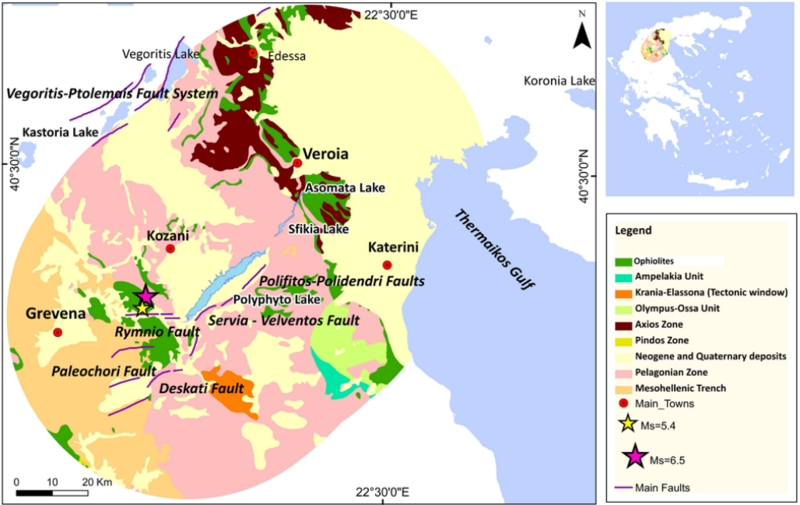
English: Map of the main geotectonic and fault zones of the broader area (50 km around the artificial lakes). A location map of the region is shown (upper right). Yellow and purple stars denote the epicenters of the 25 October 1984 and 13 May 1995 earthquakes, respectively. |
| Date | |
| Source | https://nhess.copernicus.org/articles/13/141/2013/ |
| Author | K. Pavlou, G. Kaviris, K. Chousianitis, G. Drakatos, V. Kouskouna, and K. Makropoulos |
Licensing
This file is licensed under the Creative Commons Attribution 3.0 Unported license.
- You are free:
- to share – to copy, distribute and transmit the work
- to remix – to adapt the work
- Under the following conditions:
- attribution – You must give appropriate credit, provide a link to the license, and indicate if changes were made. You may do so in any reasonable manner, but not in any way that suggests the licensor endorses you or your use.
File history
Click on a date/time to view the file as it appeared at that time.
| Date/Time | Thumbnail | Dimensions | User | Comment | |
|---|---|---|---|---|---|
| current | 11:41, 13 June 2023 | | 1,028 × 649 (454 KB) | Reego41 | Uploaded a work by K. Pavlou, G. Kaviris, K. Chousianitis, G. Drakatos, V. Kouskouna, and K. Makropoulos from https://nhess.copernicus.org/articles/13/141/2013/ with UploadWizard |
File usage
The following pages on the English Wikipedia use this file (pages on other projects are not listed):