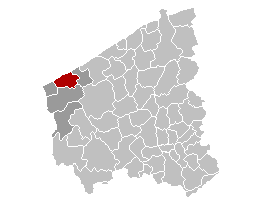
KoksijdeLocatie.png (270 × 203 pixels, file size: 5 KB, MIME type: image/png)
| This is a file from the Wikimedia Commons. Information from its description page there is shown below. Commons is a freely licensed media file repository. You can help. |

|
File:Koksijde West-Flanders Belgium Map.svg is a vector version of this file. It should be used in place of this PNG file when not inferior.
File:KoksijdeLocatie.png → File:Koksijde West-Flanders Belgium Map.svg
For more information, see Help:SVG. |
 |
Summary
| Description | Location map of the Belgian district of Koksijde |
| Date | |
| Source | nl.wikipedia.org |
| Author | LennartBolks |
| Permission (Reusing this file) |
Part of a series of map of the Netherlands released into the Public Domain [1] |
Licensing
|
This work is in the public domain in its country of origin and other countries and areas where the copyright term is the author's life plus 70 years or fewer.
| |
| This file has been identified as being free of known restrictions under copyright law, including all related and neighboring rights. | |
File history
Click on a date/time to view the file as it appeared at that time.
| Date/Time | Thumbnail | Dimensions | User | Comment | |
|---|---|---|---|---|---|
| current | 19:54, 25 March 2006 | | 270 × 203 (5 KB) | Kjetil r | - |
File usage
Global file usage
The following other wikis use this file:
- Usage on eo.wikipedia.org
- Usage on et.wikipedia.org
- Usage on fa.wikipedia.org
- Usage on it.wikipedia.org
- Usage on li.wikipedia.org
- Usage on nl.wikipedia.org
- Usage on ro.wikipedia.org
- Usage on sk.wikipedia.org
- Usage on sv.wikipedia.org
- Usage on vi.wikipedia.org
- Usage on vls.wikipedia.org