
Size of this PNG preview of this SVG file: 502 × 599 pixels. Other resolutions: 201 × 240 pixels | 402 × 480 pixels | 644 × 768 pixels | 858 × 1,024 pixels | 1,717 × 2,048 pixels | 720 × 859 pixels.
Original file (SVG file, nominally 720 × 859 pixels, file size: 62 KB)
| This is a file from the Wikimedia Commons. Information from its description page there is shown below. Commons is a freely licensed media file repository. You can help. |
| Description |
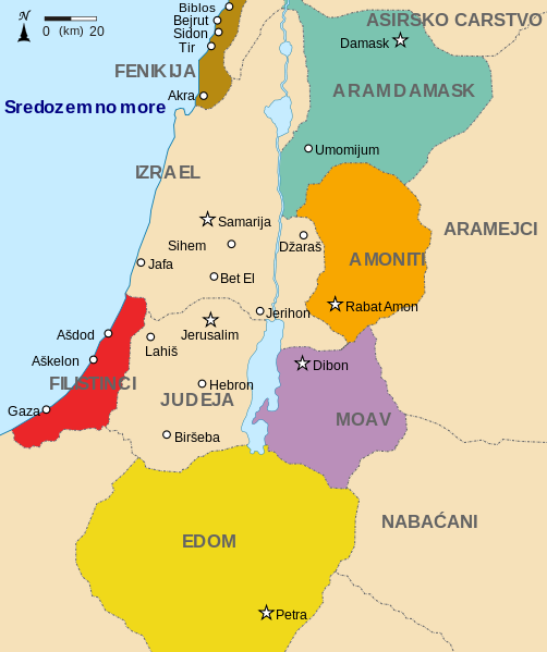
English: Map showing states around Israel and Judah. The Kingdoms around Israel and Judah are colored: * Phoenicia -Brown * Aram Damascus - Aquamarine * Amon - Orange * Moab - Purple * Edom - Yellow * Philistia - Red The map shows the region in the 9th century BCE. |
| Date | (UTC) |
| Source | |
| Author |
|
| Other versions |
[]
|


| This is a retouched picture, which means that it has been digitally altered from its original version. Modifications: translated to serbocroatian. The original can be viewed here: Kingdoms around Israel 830 map sr.svg:
|
This file is licensed under the Creative Commons Attribution-Share Alike 3.0 Unported license.
- You are free:
- to share – to copy, distribute and transmit the work
- to remix – to adapt the work
- Under the following conditions:
- attribution – You must give appropriate credit, provide a link to the license, and indicate if changes were made. You may do so in any reasonable manner, but not in any way that suggests the licensor endorses you or your use.
- share alike – If you remix, transform, or build upon the material, you must distribute your contributions under the same or compatible license as the original.
Original upload log
This image is a derivative work of the following images:
- File:Kingdoms_around_Israel_830_map_sr.svg licensed with Cc-by-sa-3.0
- 2011-07-27T03:30:56Z BokicaK 720x859 (63372 Bytes) {{Information |Description={{en|1=Map showing states around Israel and Judah. The Kingdoms around Israel and Judah are colored: * Phoenicia -Brown * Aram Damascus - Aquamarine * Amon - Orange * Moab - Purple * Edom - Yellow *
Uploaded with derivativeFX
File history
Click on a date/time to view the file as it appeared at that time.
| Date/Time | Thumbnail | Dimensions | User | Comment | |
|---|---|---|---|---|---|
| current | 04:17, 28 July 2011 | | 720 × 859 (62 KB) | BokicaK | {{Information |Description={{en|1=Map showing states around Israel and Judah. The Kingdoms around Israel and Judah are colored: * Phoenicia -Brown * Aram Damascus - Aquamarine * Amon - Orange * Moab - Purple * Edom - Yellow * Philistia - Red The map show |
File usage
No pages on the English Wikipedia use this file (pages on other projects are not listed).
Global file usage
The following other wikis use this file:
- Usage on sh.wikipedia.org
- Usage on trv.wikipedia.org