
Original file (3,700 × 4,687 pixels, file size: 5.12 MB, MIME type: image/jpeg)
| This is a file from the Wikimedia Commons. Information from its description page there is shown below. Commons is a freely licensed media file repository. You can help. |
Summary
| Description |
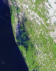
English: Residents in India’s state of Kerala are reeling from a "once-in-a-century" flood that displaced nearly a million people, caused hundreds of fatalities, and washed away homes. The region started receiving heavy rain on August 8, 2018, but news reports state that the flooding was worsened by releases from dams.
The Operational Land Imager (OLI) on the Landsat 8 satellite acquired the left image (bands 6-5-3) on February 6, 2018, before the flood. The Multispectral Instrument on the European Space Agency’s Sentinel-2 satellite acquired the right image (bands 11-8-3) on August 22, 2018, after flood water had inundated the area. The images are false-color, which makes flood water appear dark blue. Vegetation is bright green. Several rivers throughout the region spilled over their banks. Water from the Karuvannur River ran through 40 villages, and washed away a 2.2 kilometer (1.4 mile) stretch of land connecting two national highways. Elevated water levels along the Periyar River displaced thousands of people. NASA Earth Observatory images by Lauren Dauphin, using modified Copernicus Sentinel data (2018) processed by the European Space Agency and Landsat data from the U.S. Geological Survey. |
| Date | |
| Source | https://earthobservatory.nasa.gov/images/92669/before-and-after-the-kerala-floods, [File https://eoimages.gsfc.nasa.gov/images/imagerecords/92000/92669/kerala_msi_2018234_lrg.jpg] |
| Author | NASA Earth Observatory images by Lauren Dauphin, using modified Copernicus Sentinel data (2018) processed by the European Space Agency and Landsat data from the U.S. Geological Survey |
| Other versions |
|

Licensing
| This file is in the public domain in the United States because it was solely created by NASA. NASA copyright policy states that "NASA material is not protected by copyright unless noted". (See Template:PD-USGov, NASA copyright policy page or JPL Image Use Policy.) | ||
 |
Warnings:
|
File history
Click on a date/time to view the file as it appeared at that time.
| Date/Time | Thumbnail | Dimensions | User | Comment | |
|---|---|---|---|---|---|
| current | 07:06, 28 August 2018 | | 3,700 × 4,687 (5.12 MB) | Jkadavoor | {{Information |Description=Residents in India’s state of Kerala are reeling from a "once-in-a-century" flood that displaced nearly a million people, caused hundreds of fatalities, and washed away homes. The region started receiving heavy rain on August 8, 2018, but news reports state that the flooding was worsened by releases from dams. The Operational Land Imager (OLI) on the Landsat 8 satellite acquired the left image (bands 6-5-3) on February 6, 2018, before the flood. The Multispectral I... |
File usage
Global file usage
The following other wikis use this file:
- Usage on es.wikipedia.org
- Usage on ml.wikipedia.org
- Usage on or.wikipedia.org