Size of this preview: 600 × 600 pixels. Other resolutions: 240 × 240 pixels | 480 × 480 pixels | 1,000 × 1,000 pixels.
Original file (1,000 × 1,000 pixels, file size: 1.1 MB, MIME type: image/png)
| This is a file from the Wikimedia Commons. Information from its description page there is shown below. Commons is a freely licensed media file repository. You can help. |
| Description |
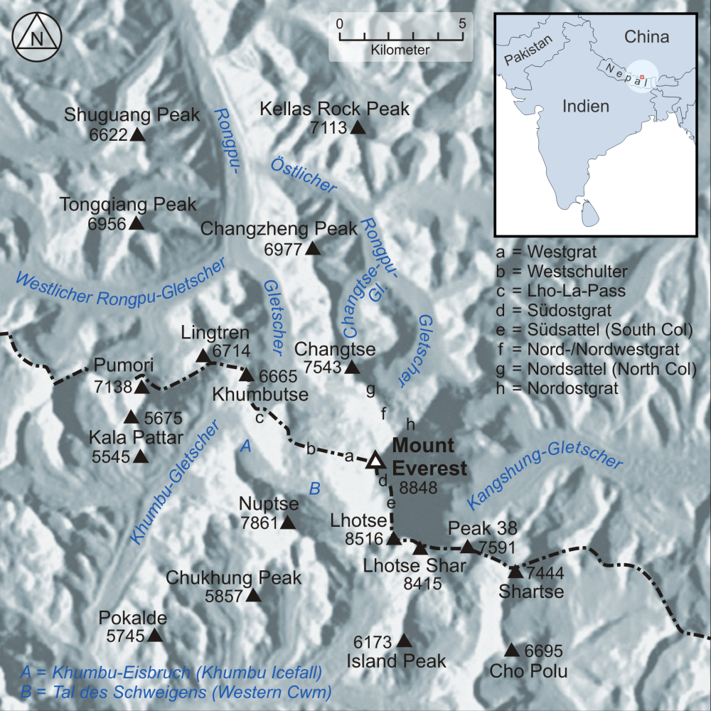
Deutsch: Karte der Region um den Mount Everest English: Map of the region surrounding Mount Everest |
| Date | |
| Source |
own work, used:
|
| Author | Lencer |

|
This map has been made or improved in the German Kartenwerkstatt (Map Lab). You can propose maps to improve as well.
|
This file is licensed under the Creative Commons Attribution-Share Alike 3.0 Unported license.
- You are free:
- to share – to copy, distribute and transmit the work
- to remix – to adapt the work
- Under the following conditions:
- attribution – You must give appropriate credit, provide a link to the license, and indicate if changes were made. You may do so in any reasonable manner, but not in any way that suggests the licensor endorses you or your use.
- share alike – If you remix, transform, or build upon the material, you must distribute your contributions under the same or compatible license as the original.

|
This map image could be re-created using vector graphics as an SVG file. This has several advantages; see Commons:Media for cleanup for more information. If an SVG form of this image is available, please upload it and afterwards replace this template with
{{vector version available|new image name}}.
It is recommended to name the SVG file “Karte Mount Everest.svg”—then the template Vector version available (or Vva) does not need the new image name parameter. |
File history
Click on a date/time to view the file as it appeared at that time.
| Date/Time | Thumbnail | Dimensions | User | Comment | |
|---|---|---|---|---|---|
| current | 07:41, 6 February 2008 | | 1,000 × 1,000 (1.1 MB) | Lencer | |
| 15:33, 16 January 2008 |  | 1,000 × 1,000 (1.09 MB) | Lencer | ||
| 14:09, 15 January 2008 |  | 1,000 × 1,000 (1.09 MB) | Lencer | ||
| 19:16, 14 January 2008 |  | 1,000 × 974 (1.1 MB) | Lencer | ||
| 14:01, 13 January 2008 |  | 1,000 × 976 (1.08 MB) | Lencer | ||
| 21:40, 10 January 2008 |  | 1,000 × 973 (1.12 MB) | Lencer | ||
| 21:20, 7 January 2008 |  | 910 × 1,000 (709 KB) | Lencer | ||
| 20:23, 7 January 2008 |  | 906 × 1,000 (709 KB) | Lencer | {{Information| |Description=Karte der region um den Mount Everest mit den Hauptbesteigungsrouten (Nordroute und Südroute) |Source=own work, used: * background created with [http://www.maps-for-free.com/ Google Maps-For-Free] SRTM3 |
File usage
The following pages on the English Wikipedia use this file (pages on other projects are not listed):
Global file usage
The following other wikis use this file:
- Usage on arz.wikipedia.org
- Usage on ba.wikipedia.org
- Usage on br.wikipedia.org
- Usage on ca.wikipedia.org
- Usage on ceb.wikipedia.org
- Usage on cs.wikipedia.org
- Usage on de.wikipedia.org
- Mount Everest
- Lhotse
- Island Peak
- Nuptse
- Pumori
- Pokalde
- Kala Patthar
- Changtse
- Cho Polu
- Tal des Schweigens
- Benutzer:Lencer
- Benutzer:Lencer/Galerie
- Lhakpa La
- Lingtren
- Khumbutse
- Khumbu-Gletscher
- Rongpu-Gletscher
- Peak 38
- Kangshung-Gletscher
- Wikipedia:Kartenwerkstatt/Archiv/2008-01
- Unglück am Mount Everest (1996)
- Britische Mount-Everest-Expedition 1922
- Britische Mount-Everest-Expedition 1924
- Benutzer:Lencer/Unterseite
- Benutzer Diskussion:PietJay/Archiv
- Diskussion:Chomo Lönzo
- John Noel
- Pethangtse
- Shartse
- Changzheng Ri
- Lixin Ri
- Tongqiang Ri
- Britische Mount-Everest-Expedition 1953
- Usage on eo.wikipedia.org
- Usage on es.wikipedia.org
- Usage on eu.wikipedia.org
- Usage on fa.wikipedia.org
- Usage on fi.wikipedia.org
- Usage on fr.wikipedia.org
View more global usage of this file.