
Size of this preview: 800 × 533 pixels. Other resolutions: 320 × 213 pixels | 640 × 427 pixels | 1,024 × 683 pixels | 1,280 × 853 pixels | 2,560 × 1,707 pixels | 4,368 × 2,912 pixels.
Original file (4,368 × 2,912 pixels, file size: 5.27 MB, MIME type: image/jpeg)
| This is a file from the Wikimedia Commons. Information from its description page there is shown below. Commons is a freely licensed media file repository. You can help. |
Summary
| Camera location | | View this and other nearby images on: OpenStreetMap |
|---|
| Description |
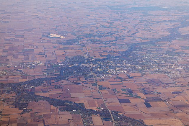
Deutsch: Kankakee, Illinos aus der Luft (Blick in westliche Richtung). Links im Bild der Zusammenfluss von Iroquois River und Kankakee River. Die Interstate 57 laeuft durch das Bild. English: Aerial photo of Kankakee, Illinois (looking westward). The confluence of Iroquois River and Kankakee River is visible on the left edge of the frame. Interstate 57 is running from right to left (north-south) through the image, the four lane road in east-west direction is Illinois Route 17. |
| Date | |
| Source | Own work |
| Author | Daniel Schwen |
| Annotations | This image is annotated: View the annotations at Commons |
Licensing
I, the copyright holder of this work, hereby publish it under the following license:
This file is licensed under the Creative Commons Attribution-Share Alike 4.0 International license.
- You are free:
- to share – to copy, distribute and transmit the work
- to remix – to adapt the work
- Under the following conditions:
- attribution – You must give appropriate credit, provide a link to the license, and indicate if changes were made. You may do so in any reasonable manner, but not in any way that suggests the licensor endorses you or your use.
- share alike – If you remix, transform, or build upon the material, you must distribute your contributions under the same or compatible license as the original.
This image has been assessed using the Quality image guidelines and is considered a Quality image.
|
File history
Click on a date/time to view the file as it appeared at that time.
| Date/Time | Thumbnail | Dimensions | User | Comment | |
|---|---|---|---|---|---|
| current | 16:03, 14 November 2008 | | 4,368 × 2,912 (5.27 MB) | Dschwen | {{Information |Description={{de|Kankakee, Illinos aus der Luft (Blick in westliche Richtung). Links im Bild der Zusammenfluss von Iroquois River und Kankakee River. Die Interstate 57 laeuft durch das Bild.}} {{en|Aerial photo of Kankakee, Illinois (lookin |
File usage
The following pages on the English Wikipedia use this file (pages on other projects are not listed):
Global file usage
The following other wikis use this file:
- Usage on de.wikipedia.org
- Usage on fr.wikipedia.org
- Usage on hu.wikipedia.org
- Usage on sv.wikipedia.org
- Usage on tl.wikipedia.org