No higher resolution available.
KTBW_loop_of_Ian's_Second_Southwest_Florida_Landfall_9-28-2022.gif (600 × 550 pixels, file size: 622 KB, MIME type: image/gif, looped, 10 frames, 3.3 s)
| This is a file from the Wikimedia Commons. Information from its description page there is shown below. Commons is a freely licensed media file repository. You can help. |
Summary
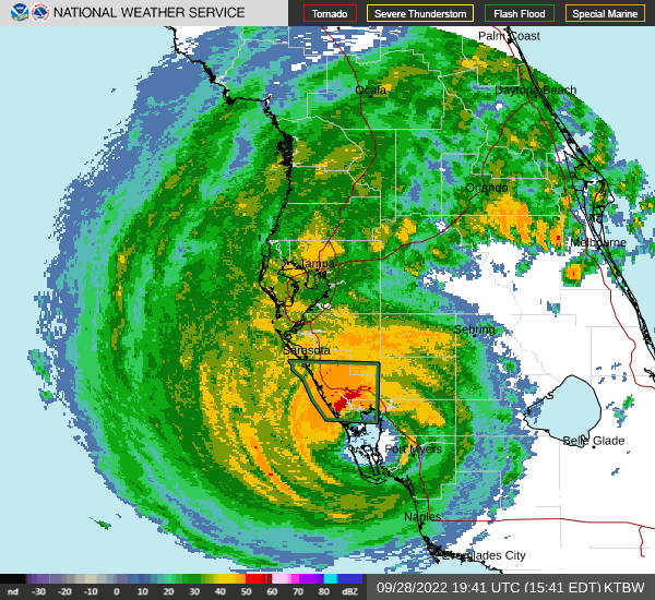
| Description |
English: Hurricane Ian makes landfall at 20:35 UTC on September 28, 2022 just south of Punta Gorda near Pirate Harbor in Southwest Florida as seen from the KTBW radar. It was at Category 4 strength with winds 145 mph and a pressure of 942 mb. |
| Date | |
| Source | https://www.weather.gov/tbw/ |
| Author | National Weather Service Tampa Bay Area, FL |
Licensing
This image is in the public domain because it is from one or more of the U.S. government’s 159 NEXRAD radars, which are jointly owned and operated by the National Weather Service (NWS), an agency of the National Oceanic and Atmospheric Administration (NOAA) within the United States Department of Commerce, the Federal Aviation Administration (FAA) within the Department of Transportation, and the U.S. Air Force within the Department of Defense.
Thus all NEXRAD images are public domain.
|
  |
File history
Click on a date/time to view the file as it appeared at that time.
| Date/Time | Thumbnail | Dimensions | User | Comment | |
|---|---|---|---|---|---|
| current | 01:08, 29 September 2022 | | 600 × 550 (622 KB) | ChessEric | Uploaded a work by National Weather Service Tampa Bay Area, FL from https://www.weather.gov/tbw/ with UploadWizard |
File usage
The following pages on the English Wikipedia use this file (pages on other projects are not listed):
Global file usage
The following other wikis use this file:
- Usage on www.wikidata.org