No higher resolution available.
KPIT_North_American_route_map.gif (720 × 360 pixels, file size: 27 KB, MIME type: image/gif)
Summary edit
| Description |
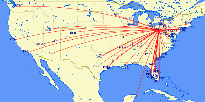
Map of routes in North America with scheduled commercial air service to/from Pittsburgh International Airport (IATA: PIT, ICAO: KPIT) |
|---|---|
| Source | |
| Date |
2020-10-31 |
| Author | |
| Permission (Reusing this file) |
http://www.gcmap.com/faq/using#wikipedia
|
Licensing edit
| The copyright holder of this file, Great Circle Mapper, allows anyone to use it for any purpose, provided that the copyright holder is properly attributed. Redistribution, derivative work, commercial use, and all other uses are permitted. |
| This media file is either in the public domain or published under a free license, and contains no inbound file links. If this media file is useful, then it should be transferred to the Wikimedia Commons. If this media is not useful, then please propose it for deletion or list it at files for discussion. |
File history
Click on a date/time to view the file as it appeared at that time.
| Date/Time | Thumbnail | Dimensions | User | Comment | |
|---|---|---|---|---|---|
| current | 23:08, 31 October 2020 | | 720 × 360 (27 KB) | TEMPO156 (talk | contribs) | Uploading a file from a free published source using File Upload Wizard |
You cannot overwrite this file.
File usage
No pages on the English Wikipedia use this file (pages on other projects are not listed).