File:Jamaica, particulars and conditions of sale of valuable Sugar Estate - known as "Trinity Plantation," "Roslyn Pen," "Cromwell Plantation," and Cromwell Mountain," all sutuate in the Parish of St. LOC 2016586802-3.jpg

Size of this preview: 468 × 599 pixels. Other resolutions: 187 × 240 pixels | 375 × 480 pixels | 600 × 768 pixels | 799 × 1,024 pixels | 1,599 × 2,048 pixels | 5,111 × 6,546 pixels.
Original file (5,111 × 6,546 pixels, file size: 2.59 MB, MIME type: image/jpeg)
| This is a file from the Wikimedia Commons. Information from its description page there is shown below. Commons is a freely licensed media file repository. You can help. |
Summary
| Description |
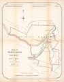
English: Title from accompanying text. "In the matter of the Estate of Joseph Gilbert da Costa, deceased. Exparte George Thomson abd another, petitioners." "Sale on Wednesday, 25th November, 1874." Accompanied by text: In the Court of the Commissioners for Sale of Incumbered Estates in the West Indies, Jamaica. ([4] unnumbered pages : cadastral data, annotations ; 45 cm, folded to 28 x 12 cm). "The Auction Mart, Tokenhouse Yard, Lothbury, in the city of London, on Wednesday, the 25th day of November, 1874, at one o'clock precisely. The purchaser will have an indefeasible Parliamentary Title under the Seal of the Court." Copy imperfect: Use-worn, torn along fold lines, cover of accompanying text detached. Available also through the Library of Congress Web site as a raster image. |
||
| Title | Jamaica, particulars and conditions of sale of valuable Sugar Estate : known as "Trinity Plantation," "Roslyn Pen," "Cromwell Plantation," and Cromwell Mountain," all sutuate in the Parish of St. Mary, in the Island of Jamaica, containing together 2,547 acres or thereabouts : together with the centrifugal machinery, plant, fixtures, live and dead stock, and other chattels and effects : which will by sold by auction, in four lots, by Messrs. Hards, Vaughan, & Jenkinson, before James Flemeing, Esq., Q.C., and Reginald John Cust, Esq., Commissioners for Sale of Incumbered Estates in the West Indies, at the Sale Room of the Commissioners. and mountain Estates Jamaica. | ||
| Shelf ID | G4961.G46 1874 .H3 | ||
| Parent | https://www.loc.gov/resource/g4961gm.gct00423/ | ||
| Sheet title | Plan of Woodstock Pen | ||
| Date | |||
| Source | https://www.loc.gov/item/2016586802/ | ||
| Author | Hards, Vaughan & Jenkinson (Firm) | ||
| Permission (Reusing this file) |
|
||
| Other versions |
|
||
| Location | Jamaica · Jamaica. | ||
| Part of | American Memory · Catalog · County Landownership Maps · Geography And Map Division · Cultural Landscapes | ||
| Subject | Cadastral Maps · Sir · Jamaica · Sugarcane · Maps · Cust, Reginald John · Estates · Owner · Real Property · Landowners |

Licensing
|
This is a faithful photographic reproduction of a two-dimensional, public domain work of art. The work of art itself is in the public domain for the following reason:
The official position taken by the Wikimedia Foundation is that "faithful reproductions of two-dimensional public domain works of art are public domain".
This photographic reproduction is therefore also considered to be in the public domain in the United States. In other jurisdictions, re-use of this content may be restricted; see Reuse of PD-Art photographs for details. | ||||
File history
Click on a date/time to view the file as it appeared at that time.
| Date/Time | Thumbnail | Dimensions | User | Comment | |
|---|---|---|---|---|---|
| current | 03:59, 20 May 2018 | | 5,111 × 6,546 (2.59 MB) | Fæ | LOC Maps https://www.loc.gov/item/2016586802/ sheet 3 of 11 #273 |
File usage
The following pages on the English Wikipedia use this file (pages on other projects are not listed):