No higher resolution available.
JNU-a.jpg (608 × 352 pixels, file size: 261 KB, MIME type: image/jpeg)
| This is a file from the Wikimedia Commons. Information from its description page there is shown below. Commons is a freely licensed media file repository. You can help. |
Summary
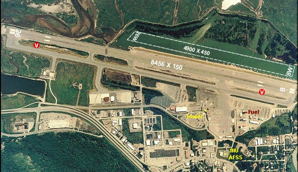
| Description |
English: Juneau (JNU) Airport Overhead |
| Date | Data: Nov 2001 |
| Source | http://www.alaska.faa.gov/fai/images/SEAK/JNU-a.jpg |
| Author | Federal Aviation Administration, Alaska |
Juneau, Alaska 99801
| Camera location | | View this and other nearby images on: OpenStreetMap |
|---|
Licensing
This image or file is a work of a Federal Aviation Administration employee, taken or made as part of that person's official duties. As a work of the U.S. federal government, the image is in the public domain in the United States.
|
 |
File history
Click on a date/time to view the file as it appeared at that time.
| Date/Time | Thumbnail | Dimensions | User | Comment | |
|---|---|---|---|---|---|
| current | 18:34, 25 July 2012 | | 608 × 352 (261 KB) | Zyxw | cropped to display only the aerial photo; image used in infoboxes and text not needed |
| 10:36, 10 June 2008 |  | 609 × 609 (371 KB) | LeheckaG | {{Information |Description={{en|1=Juneau (JNU) Airport Overhead}} |Source=http://www.alaska.faa.gov/fai/images/SEAK/JNU-a.jpg |Author=Federal Aviation Administration, Alaska |Date=Data: Nov 2001 |Permission= |other_versions= }} Juneau, Alaska 99801 {{Loc |
File usage
The following pages on the English Wikipedia use this file (pages on other projects are not listed):
Global file usage
The following other wikis use this file:
- Usage on de.wikipedia.org
- Usage on es.wikipedia.org
- Usage on fa.wikipedia.org
- Usage on id.wikipedia.org
- Usage on ja.wikipedia.org
- Usage on ru.wikipedia.org
- Usage on tg.wikipedia.org
- Usage on ur.wikipedia.org
- Usage on zh.wikipedia.org