Size of this preview: 775 × 600 pixels. Other resolutions: 310 × 240 pixels | 621 × 480 pixels | 795 × 615 pixels.
Original file (795 × 615 pixels, file size: 104 KB, MIME type: image/jpeg)
| This is a file from the Wikimedia Commons. Information from its description page there is shown below. Commons is a freely licensed media file repository. You can help. |
Summary
| Description |
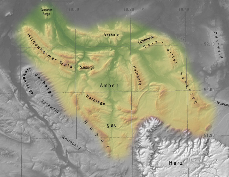
Deutsch: Topographische Karte vom Innerstebergland (nur Gelände) |
| Date | |
| Source | selbst erstellt aus SRTM-Daten |
| Author | Langläufer 09:57, 29. Okt. 2006 (CET) |
Licensing
Langläufer at the German-language Wikipedia, the copyright holder of this work, hereby publishes it under the following license:

|
Permission is granted to copy, distribute and/or modify this document under the terms of the GNU Free Documentation License, Version 1.2 or any later version published by the Free Software Foundation; with no Invariant Sections, no Front-Cover Texts, and no Back-Cover Texts. A copy of the license is included in the section entitled GNU Free Documentation License. |
| This file is licensed under the Creative Commons Attribution-Share Alike 3.0 Unported license. | ||
| Attribution: Langläufer | ||
| ||
| This licensing tag was added to this file as part of the GFDL licensing update. |
Original upload log
The original description page was here. All following user names refer to de.wikipedia.
- 2006-12-12 21:04 Langläufer 795×615× (106695 bytes) und nochmal
- 2006-12-12 20:57 Langläufer 795×615× (107058 bytes) update der Farben
- 2006-12-11 23:13 Langläufer 795×615× (106405 bytes) update
- 2006-12-11 21:57 Langläufer 795×615× (104104 bytes) überarbeitet
- 2006-10-29 08:57 Langläufer 795×615× (207945 bytes) {{Information |Beschreibung=Geländemodell vom [[Innerstebergland]] |Quelle= |Urheber=~~~~ |Datum=30.10.2006 |Genehmigung= |Andere Versionen= |Anmerkungen=Unter Verwendung von [[SRTM-Daten]], uns Visualisierungssoftware 3dem }}
File history
Click on a date/time to view the file as it appeared at that time.
| Date/Time | Thumbnail | Dimensions | User | Comment | |
|---|---|---|---|---|---|
| current | 21:59, 13 December 2011 | | 795 × 615 (104 KB) | OgreBot | (BOT): Reverting to most recent version before archival |
| 21:59, 13 December 2011 |  | 795 × 615 (105 KB) | OgreBot | (BOT): Uploading old version of file from de.wikipedia; originally uploaded on 2006-12-12 20:57:21 by Langläufer | |
| 21:59, 13 December 2011 |  | 795 × 615 (104 KB) | OgreBot | (BOT): Uploading old version of file from de.wikipedia; originally uploaded on 2006-12-11 23:13:06 by Langläufer | |
| 21:59, 13 December 2011 |  | 795 × 615 (102 KB) | OgreBot | (BOT): Uploading old version of file from de.wikipedia; originally uploaded on 2006-12-11 21:57:29 by Langläufer | |
| 21:59, 13 December 2011 |  | 795 × 615 (203 KB) | OgreBot | (BOT): Uploading old version of file from de.wikipedia; originally uploaded on 2006-10-29 08:57:59 by Langläufer | |
| 16:08, 22 October 2011 |  | 795 × 615 (104 KB) | Bermicourt | {{Information |Description={{de|Topographische Karte vom de:Innerstebergland (nur Gelände)}} |Source=Transferred from [http://de.wikipedia.org de.wikipedia]<br/> (Original text : ''selbst erstellt aus de:SRTM-Daten'') |Date=30.10.2006<br/> ({ |
File usage
The following pages on the English Wikipedia use this file (pages on other projects are not listed):
Global file usage
The following other wikis use this file:
- Usage on bg.wikipedia.org
- Usage on de.wikipedia.org
- Usage on nl.wikipedia.org
- Usage on www.wikidata.org