
Size of this preview: 800 × 532 pixels. Other resolutions: 320 × 213 pixels | 640 × 425 pixels | 1,024 × 681 pixels | 1,280 × 851 pixels | 2,560 × 1,701 pixels | 4,288 × 2,850 pixels.
Original file (4,288 × 2,850 pixels, file size: 2.27 MB, MIME type: image/jpeg)
| This is a file from the Wikimedia Commons. Information from its description page there is shown below. Commons is a freely licensed media file repository. You can help. |
Summary
| Description |
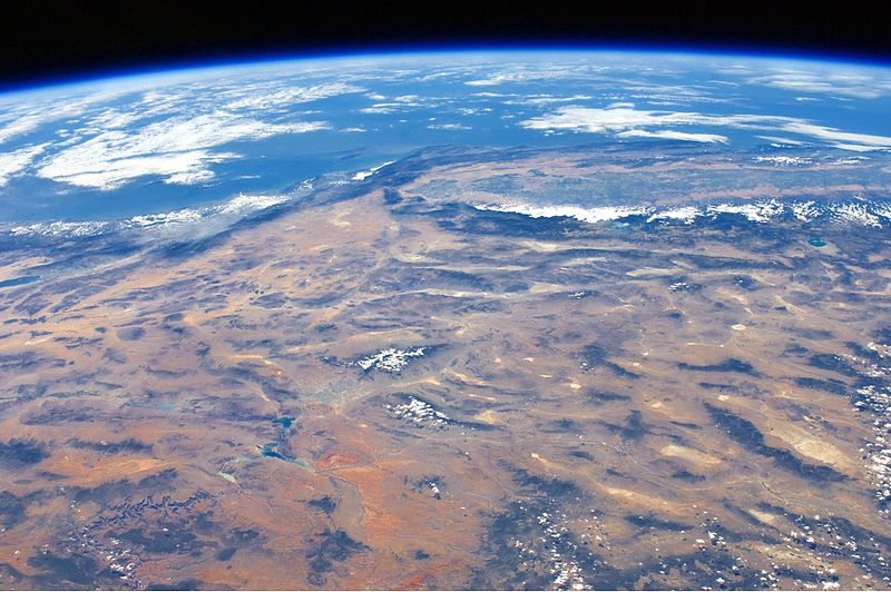
English: This panoramic view of the south-western United States and Pacific Ocean was taken by an astronaut looking out at an angle from the International Space Station (ISS). The image includes parts of Arizona, Nevada, Utah, and California, as well the coastline of Baja California, Mexico (image centre left). The Las Vegas metropolitan area appears as a gray region adjacent to the Spring Mountains and Sheep Range (both covered by white clouds). The Grand Canyon, located on the Colorado Plateau in Arizona, is visible to the east of Las Vegas, with the blue waters of Lake Mead in between.
The image also includes the Mojave Desert, stretching north from the Salton Sea to the Sierra Nevada mountain range. The Sierra Nevada is roughly 640 km long (north-south) and forms the boundary between the Central Valley of California and the adjacent Basin and Range physiographic province. The Basin and Range is so called because of the pattern of long linear valleys separated by parallel mountain ranges. The landscape was formed by extension and thinning of the Earth’s crust. |
| Date | |
| Source | NASA Earth Observatory |
| Author | ISS Expedition 24 crew |
| Camera location | | View this and other nearby images on: OpenStreetMap |
|---|
This image or video was catalogued by Johnson Space Center of the United States National Aeronautics and Space Administration (NASA) under Photo ID: ISS024-E-14071. This tag does not indicate the copyright status of the attached work. A normal copyright tag is still required. See Commons:Licensing. Other languages:
|
Image acquired with a Nikon D2Xs digital camera using a 32 mm lens, and is provided by the ISS Crew Earth Observations experiment and Image Science & Analysis Laboratory, Johnson Space Center.
Licensing
| This file is in the public domain in the United States because it was solely created by NASA. NASA copyright policy states that "NASA material is not protected by copyright unless noted". (See Template:PD-USGov, NASA copyright policy page or JPL Image Use Policy.) | ||
 |
Warnings:
|
| Annotations | This image is annotated: View the annotations at Commons |
File history
Click on a date/time to view the file as it appeared at that time.
| Date/Time | Thumbnail | Dimensions | User | Comment | |
|---|---|---|---|---|---|
| current | 12:36, 4 October 2010 | | 4,288 × 2,850 (2.27 MB) | Originalwana | {{Information |Description={{en|1=This panoramic view of the south-western United States and Pacific Ocean was taken by an astronaut looking out at an angle from the International Space Station (ISS). The image includes parts of Arizona, [ |
File usage
The following pages on the English Wikipedia use this file (pages on other projects are not listed):
Global file usage
The following other wikis use this file:
- Usage on he.wikipedia.org