
Size of this PNG preview of this SVG file: 350 × 370 pixels. Other resolutions: 227 × 240 pixels | 454 × 480 pixels | 726 × 768 pixels | 969 × 1,024 pixels | 1,937 × 2,048 pixels.
Original file (SVG file, nominally 350 × 370 pixels, file size: 11 KB)
| This is a file from the Wikimedia Commons. Information from its description page there is shown below. Commons is a freely licensed media file repository. You can help. |
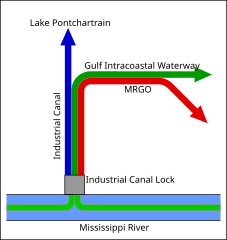
| Description | Schematic diagram of the Inner Harbor Navigation Canal, commonly known as the Industrial Canal, in New Orleans, Louisiana, USA. The diagram shows the connections between the canal and the Mississippi River, Lake Pontchartrain, the Gulf Intracoastal Waterway, and the Mississippi River Gulf Outlet (MRGO). | ||||||||
| Date | |||||||||
| Source | Created by myself, D. M. Short, based on a similar PNG drawing by Wikipedia Commons user Muffuletta (see Image:IHNCconfluence.png, 2006-03-20) | ||||||||
| Author | D. M. Short | ||||||||
| Permission (Reusing this file) |
I, the copyright holder of this work, hereby publish it under the following licenses:
You may select the license of your choice. |
||||||||
| Other versions | PNG version: Image:IHNCconfluence.png |

File history
Click on a date/time to view the file as it appeared at that time.
| Date/Time | Thumbnail | Dimensions | User | Comment | |
|---|---|---|---|---|---|
| current | 00:21, 11 April 2007 | | 350 × 370 (11 KB) | DanMS | {{Information | Description = Schematic diagram of the Inner Harbor Navigation Canal, commonly known as the Industrial Canal, in New Orleans, Louisiana, USA. The diagram shows the connections between the canal and the Mississippi River, Lake Pontchartr |
File usage
The following pages on the English Wikipedia use this file (pages on other projects are not listed):
Global file usage
The following other wikis use this file:
- Usage on fr.wikipedia.org
- Usage on nl.wikipedia.org