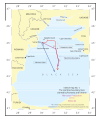
Size of this PNG preview of this SVG file: 503 × 599 pixels. Other resolutions: 201 × 240 pixels | 403 × 480 pixels | 645 × 768 pixels | 860 × 1,024 pixels | 1,720 × 2,048 pixels | 535 × 637 pixels.
Original file (SVG file, nominally 535 × 637 pixels, file size: 442 KB)
File history
Click on a date/time to view the file as it appeared at that time.
| Date/Time | Thumbnail | Dimensions | User | Comment | |
|---|---|---|---|---|---|
| current | 21:32, 6 May 2010 |  | 535 × 637 (442 KB) | DieBuche | added 1940 border |
| 21:22, 6 May 2010 |  | 535 × 637 (565 KB) | DieBuche | adding border (according to ICJ) | |
| 21:06, 6 May 2010 |  | 535 × 637 (1.63 MB) | DieBuche | {{Information |Description=Ukrainian-Romanian maritime boundary |Source=[http://www.icj-cij.org/docket/files/132/14985.pdf?PHPSESSID=87e357fcf3c2d689819cbb3c1b658684] |Date=03-02-2009 |Author=DieBuche |Permission= |other_versions= }} |
File usage
The following page uses this file:
Global file usage
The following other wikis use this file:
- Usage on be-tarask.wikipedia.org
- Usage on be.wikipedia.org
- Usage on es.wikipedia.org
- Usage on fr.wikipedia.org
- Usage on it.wikipedia.org
- Usage on ja.wikipedia.org
- Usage on ro.wikipedia.org
- Usage on ru.wikipedia.org
- Usage on uk.wikipedia.org
- Usage on www.wikidata.org